
Oklahoma Including OKC Faces Severe Storm Risk Wednesday 2–6 PM With 2-Inch Hail, Low Tornado Threat, and Storms Clearing East After 6 PM
OKLAHOMA — A Wednesday severe weather risk update is in effect across Oklahoma as storms are expected to fire earlier today compared to recent days. Areas west of Oklahoma City could see storm activity as early as 1 to 2 PM, with OKC itself facing its primary window of concern between 4 and 6 PM. Storms will then push east of OKC after 6 PM and gradually move away from the region through the evening hours.
Storms Fire Earlier Today Across Western Oklahoma
Unlike the last few days where severe storms failed to materialize, today presents a fresh and more favorable setup for storm development. Convective debris from Tuesday’s Texas storms, which brought clouds, light rain, and sinking air over OKC, is no longer a factor today.
Storms are expected to initiate as early as 1 to 2 PM west of Oklahoma City, spreading eastward through the afternoon. Residents west of OKC in areas including Clinton, Hobart, Altus, and Lawton should be weather-aware from early afternoon onward.
OKC Primary Storm Window Runs 4 to 6 PM
For Oklahoma City and surrounding communities, the peak window of concern falls between 4 and 6 PM Wednesday. This is when the most organized and potentially severe storms are expected to impact the metro area directly.
After 6 PM, storms are forecast to shift east of OKC toward Seminole, Ada, McAlester, and beyond, gradually moving away from the city as the evening progresses. Residents east of OKC should remain alert through the 6 to 8 PM window.
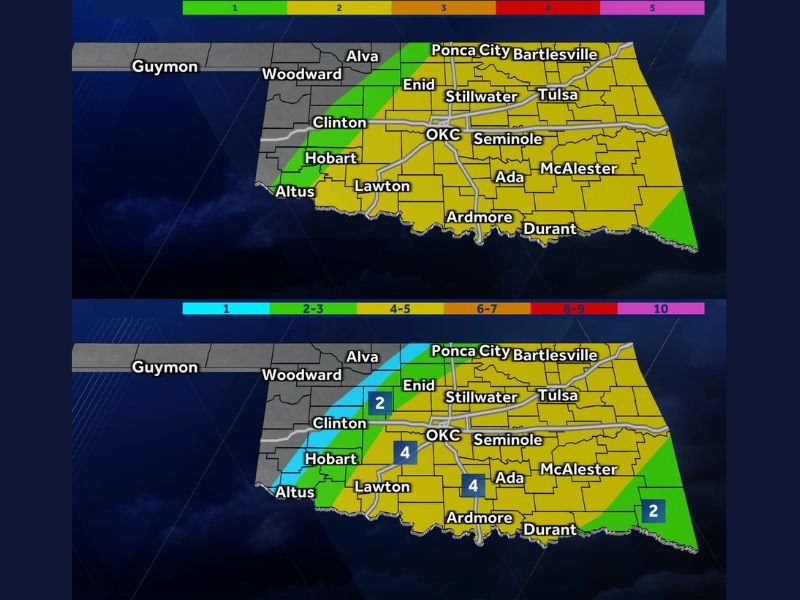
Two-Inch Hail and Low Tornado Risk Are Primary Threats
The severe risk for Wednesday includes the potential for 2-inch diameter hail, which falls in the golf ball to larger size range and is capable of causing significant damage to vehicles, rooftops, and anything left outdoors. The hail risk map shows the highest concentration centered around OKC and extending into Tulsa and surrounding areas.
A low but real tornado risk also exists across the region. The Tornado Index shows elevated values of 4 across the Hobart and Lawton areas, with a score of 2 covering OKC, Tulsa, and the broader eastern portions of the state. Residents should have shelter plans ready before the afternoon storm window opens.
Severe Storm Timeline Shows Fast-Moving System
The Severe Storm Timeline for Wednesday clearly illustrates the eastward progression of storm activity throughout the day. The 2 to 4 PM window covers western areas, the 4 to 6 PM window targets OKC and central Oklahoma, and the 6 to 8 PM window shifts the threat into eastern portions of the state including Bartlesville, Tulsa, and surrounding communities.
Morning precipitation chances between 8 AM and noon remain modest, ranging from 20 to 30 percent across most of the state, keeping the atmosphere primed without significantly disrupting storm development potential heading into the afternoon.
Bigger Risk Still to Come Friday
While Wednesday’s storm threat is significant, forecasters are already flagging an even larger severe weather risk on the horizon for Friday. Details on that system will be released as the forecast period approaches, but residents are advised to stay tuned and keep preparedness measures in place through the end of the week. Stay with NapervilleLocal.com for the latest weather updates and local forecast coverage.

I’ve lived in Naperville long enough to see how quickly our community changes — from new developments downtown to sudden shifts in our Midwest weather. Reporting on Naperville news and daily forecasts gives me the chance to keep neighbors informed about what really matters. My goal is simple: deliver clear, timely updates so you always know what’s happening in our city and what to expect from the skies above.