
North and Central Alabama Including Birmingham and Tuscaloosa to See Weekend Rain Saturday Evening Through Sunday Morning With Totals Reaching Up to 1 Inch
NORTH AND CENTRAL ALABAMA — A Wednesday night weather update confirms that rain and thunderstorms are looking increasingly likely for the weekend across North and Central Alabama.
The primary window for rainfall is Saturday evening through Sunday morning, with storm activity already visible on future track models around 9:30 PM Saturday across the Birmingham metro, Tuscaloosa, Jasper, Cullman, and Gadsden areas. While the rain will disrupt Saturday night outdoor plans, it brings welcome moisture to a region battling ongoing drought conditions.
Saturday Evening Brings the Heaviest Storm Activity
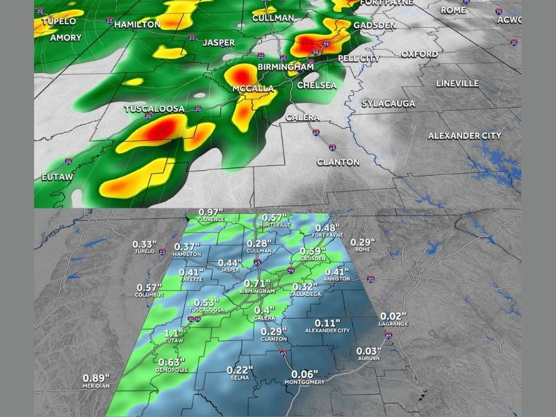
Future track data for Saturday at 9:30 PM shows a well-organized band of rain and thunderstorms pushing through North and Central Alabama during the evening hours. The heaviest activity is concentrated around Birmingham, McCalla, Chelsea, Tuscaloosa, and Jasper, where radar returns show the most intense rainfall cores.
The storm band extends northward through Cullman and Gadsden and southward through Calera and Clanton, covering a wide swath of the state during the Saturday night hours. Residents with outdoor events planned for Saturday evening should prepare for a significant disruption.
Rain Totals Expected to Reach Half an Inch to One Inch by Sunday Morning
By Sunday at 6:30 AM, rainfall totals across North and Central Alabama are forecast to be meaningful and widespread. Florence leads the totals at 0.97 inches, with Birmingham expected to pick up 0.71 inches and Tuscaloosa reaching 0.53 inches.
Other notable totals include Eutaw at 1.1 inches, Fayette at 0.41 inches, Jasper at 0.44 inches, Gadsden at 0.59 inches, and Huntsville at 0.57 inches. Southern portions of the state including Montgomery, Selma, and Clanton will see lighter totals ranging from 0.06 to 0.29 inches, while far eastern areas like LaGrange and Auburn will receive little to no measurable rainfall from this system.
Good News for Drought Relief but More Rain Still Needed
The incoming rainfall represents a positive development for a region that has been dealing with drought conditions. Totals ranging from half an inch to just over one inch across the hardest-hit areas will provide some relief, though forecasters acknowledge it will not be enough to fully erase the moisture deficit built up over recent weeks.
Even better news comes in the extended outlook, where an even stronger chance of rain is expected next week and next weekend. That additional rainfall event could prove more impactful in terms of making a meaningful dent in the ongoing drought across the state.
Saturday Night Outdoor Plans Face Disruption
The timing of this system will be particularly problematic for anyone with Saturday evening outdoor events scheduled across North and Central Alabama. The heaviest rain is expected to arrive during prime evening hours and may also impact some events planned for next weekend depending on how the following system tracks.
Residents are advised to have backup plans ready for Saturday night activities and to monitor updated forecasts closely as the weekend approaches for any timing adjustments. Stay with NapervilleLocal.com for the latest weather updates and local forecast coverage.

I’ve lived in Naperville long enough to see how quickly our community changes — from new developments downtown to sudden shifts in our Midwest weather. Reporting on Naperville news and daily forecasts gives me the chance to keep neighbors informed about what really matters. My goal is simple: deliver clear, timely updates so you always know what’s happening in our city and what to expect from the skies above.