
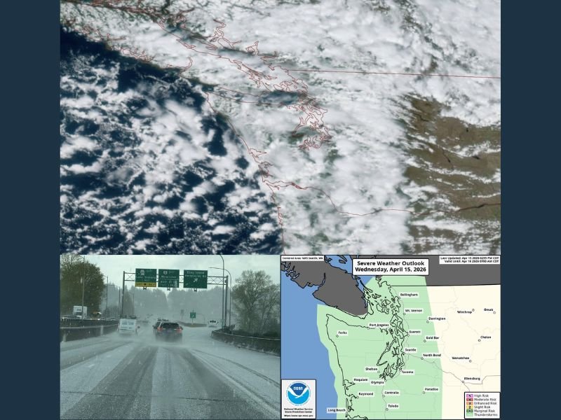
Puget Sound and Seattle Area Hit by Rare Thunderstorms Wednesday With Heavy Rain, Gusty Winds, and Small Hail Before Frost and Freeze Threat Overnight
PUGET SOUND, WASHINGTON — A rare thunderstorm event is impacting the Puget Sound region this Wednesday, April 15, 2026, catching many residents off guard with rumbles of thunder, bursts of heavy rain, gusty winds, and small hail. Seattle and the broader Puget Sound area do not see thunderstorms frequently, but a combination of cool unstable air, surface heating from sunshine, and converging winds following Tuesday’s storm has created the perfect recipe for this unusual weather event.
North Sound and Kitsap Peninsula See the Most Active Storms
The most intense storm activity so far has been concentrated across the North Sound and over the Kitsap Peninsula. Reports of hail were received around Everett earlier in the day, with that activity setting the stage for the broader storm development now affecting the region.
Seattle and the rest of the Puget Sound area are still in line to experience their own rounds of thunder through the evening hours. Any storm that moves through could bring bursts of heavy rain, gusty winds, small hail, and frequent lightning in addition to the thunder already rattling windows across the region.
Cool Unstable Air and Converging Winds Fuel the Storms
The atmospheric setup behind Wednesday’s rare thunderstorm event involves several ingredients coming together simultaneously. Cool and unstable air poured into the region following Tuesday’s storm system, providing the raw instability needed for convective development.
Add in a few breaks of sunshine warming the ground surface and converging winds focusing lift over the area, and the result is a classic Western Washington thunderstorm — uncommon but entirely possible during this time of year when the right conditions align.
Storms Subside After Sunset, Skies Clear Overnight
The thunderstorm activity is expected to hang around through sunset Wednesday evening before gradually subsiding as instability weakens with the loss of daytime heating. Once the storms clear, skies are expected to improve overnight, setting the stage for a much calmer Thursday ahead.
However, the chilly air mass responsible for fueling the instability will remain firmly in place after the storms exit. That combination of clearing skies and cold air will allow temperatures to drop sharply overnight.
Frost and Freeze Threat Overnight for Seattle and Outlying Areas
With storms clearing and cold air in place, a frosty morning is possible around Seattle heading into Thursday. Outlying areas surrounding the city face an even greater risk, with temperatures potentially dropping to freezing or below in some locations overnight.
Residents with sensitive plants, gardens, or outdoor vegetation should take protective measures before temperatures fall Wednesday night. The freeze threat is most significant away from the urban core where the heat island effect provides some insulation against the coldest readings.
Dry and Sunny Thursday and Friday Before Weekend Rain Returns
Following the stormy Wednesday and frosty Thursday morning, conditions will improve significantly heading into the second half of the week. Thursday and Friday are both expected to be dry and reasonably sunny, offering a welcome break from the active weather pattern.
Friday morning may bring another frosty start similar to Thursday, so residents should remain aware of the cold overnight temperatures persisting through the end of the week. Clouds will then return on Saturday, followed by a chance of rain on Sunday as the next weather system approaches the region. Stay with NapervilleLocal.com for the latest weather updates and local forecast coverage.

I’ve lived in Naperville long enough to see how quickly our community changes — from new developments downtown to sudden shifts in our Midwest weather. Reporting on Naperville news and daily forecasts gives me the chance to keep neighbors informed about what really matters. My goal is simple: deliver clear, timely updates so you always know what’s happening in our city and what to expect from the skies above.