
Kentucky and Southern Indiana Face Two-Round Storm Threat Thursday With 60 MPH Gusts and Small Hail Possible but Zero Tornado Risk
KENTUCKY AND SOUTHERN INDIANA — A stormy Thursday is ahead for Kentucky and Southern Indiana as two separate rounds of weather move through the region on April 16, 2026. The morning brings a weaker pulse of windy thundershowers, while the afternoon delivers a more organized round of thunderstorms capable of small hail and wind gusts up to 60 MPH. Forecasters are firm that there is zero tornado threat associated with either round of Thursday’s storm activity.
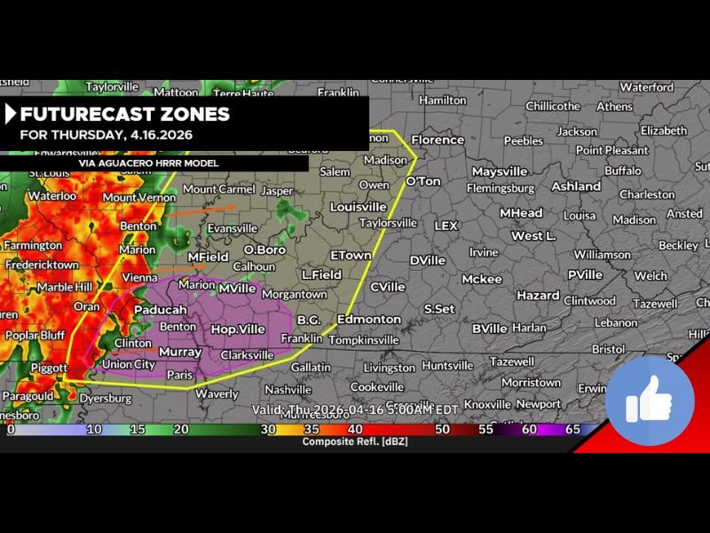
Morning Round Brings Windy Thundershowers 5 to 11 AM
The first round of weather moves through between 5 and 11 AM ET, tracking from west to east across the region. This morning pulse falls within the Yellow Zone on the Futurecast map and is expected to weaken as it progresses eastward through the morning hours.
No major severe concerns are associated with the morning round. Residents can expect gusty winds and heavy rain at times but should not anticipate any significant severe weather impacts during this first wave of activity.
Afternoon Thunderstorms Bring the Greater Threat 3 to 7 PM
The second and more impactful round arrives during the afternoon hours between 3 and 7 PM ET. This pulse carries a more organized and energetic storm structure, falling within the Pink Zone on the Futurecast map covering portions of western and central Kentucky including Paducah, Hopkinsville, Bowling Green, Evansville, and surrounding areas.
Storms during this window are capable of producing very brief small hail and wind gusts reaching up to 60 MPH. The combination of gusty winds and hail during the afternoon commute window means residents across the Pink Zone should plan accordingly and avoid unnecessary travel during peak storm hours.
Zero Tornado Threat Confirmed for Thursday
Forecasters have been explicit and clear on one key point — there is absolutely zero tornado threat associated with Thursday’s storm activity. Despite two rounds of storms and the potential for 60 MPH wind gusts in the afternoon, atmospheric conditions are not supportive of any tornado development throughout the day.
This is an important distinction from recent storm events across the region and should provide some reassurance to residents who have been on high alert for rotating storms during the past several days.
Louisville and Central Kentucky in the Yellow Zone
The Futurecast Zone map places Louisville and central Kentucky communities including Elizabethtown, Campbellsville, and surrounding areas within the Yellow Zone for Thursday. This zone covers the morning round of thundershowers as well as the trailing edge of afternoon storm activity pushing east.
Storm intensity across the Yellow Zone is expected to be lower compared to the Pink Zone further west, with the primary impacts being gusty winds and heavy rainfall rather than the more organized severe cells expected further to the west and southwest.
Prepare for a Stormy Day Across the Region
Despite the zero tornado risk, Thursday still presents a disruptive weather day across Kentucky and Southern Indiana. Residents should prepare for two separate rounds of storms, plan outdoor activities around the 5 to 11 AM and 3 to 7 PM windows, and be ready for brief but gusty winds and limited visibility during the heavier rain periods throughout the day. Stay with NapervilleLocal.com for the latest weather updates and local forecast coverage.

I’ve lived in Naperville long enough to see how quickly our community changes — from new developments downtown to sudden shifts in our Midwest weather. Reporting on Naperville news and daily forecasts gives me the chance to keep neighbors informed about what really matters. My goal is simple: deliver clear, timely updates so you always know what’s happening in our city and what to expect from the skies above.