
Wilkes-Barre and Scranton Facing Severe Storm Line Through Midnight With 60 MPH Winds, Torrential Rain, and Power Outage Risk
NORTHEASTERN PENNSYLVANIA — A line of strong to severe storms is pushing through Northeastern Pennsylvania as of 11:06 PM on April 15, 2026, with the threat continuing through midnight. The fast-moving system is bringing wind gusts up to 60 MPH, torrential rainfall, and frequent lightning across the region. Power outages are considered likely due to the intensity of the wind gusts accompanying the storm line.
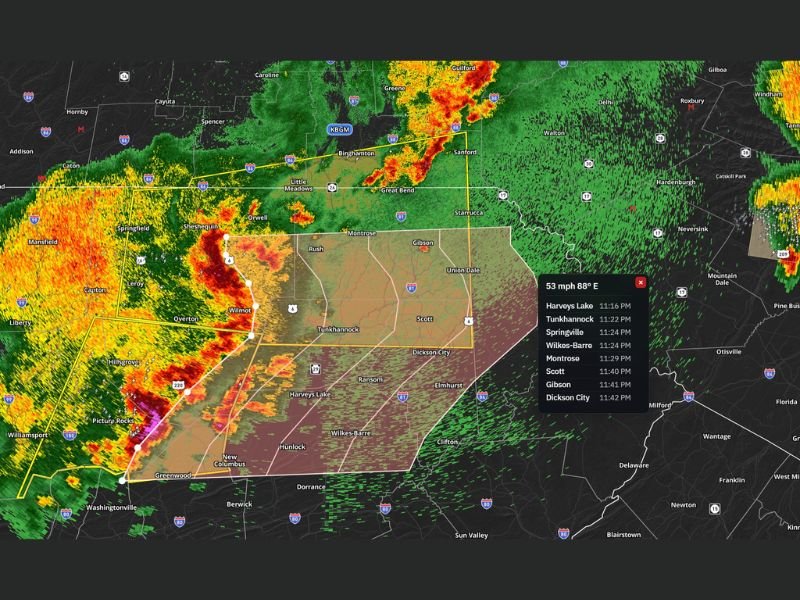
Storm Timeline Shows Fast-Moving System Through Midnight
Radar tracking data shows a precise and rapidly moving storm progression through the region. Harveys Lake is being impacted at 11:16 PM, followed by Tunkhannock at 11:22 PM and Springville at 11:24 PM.
Wilkes-Barre and Montrose are both expected to see the line arrive around 11:24 to 11:29 PM, with Scott and Gibson hit at 11:40 and 11:41 PM respectively. Dickson City rounds out the timeline at 11:42 PM, with the entire line expected to push through the Wilkes-Barre and Scranton corridor between 11:40 and 11:55 PM.
Wind Gusts Up to 60 MPH and Torrential Rain Expected
The primary threats with this storm line are significant and impactful. Wind gusts reaching up to 60 MPH are capable of downing trees, snapping branches, and sending debris airborne across affected communities.
Torrential rainfall will accompany the wind, reducing visibility significantly during the passage of the line. Frequent lightning is also embedded within the system, adding an additional hazard for anyone caught outdoors during the storm’s arrival.
Power Outages Likely Across the Region
Given the intensity of the wind gusts moving through the area, power outages are considered a likely outcome across Northeastern Pennsylvania through midnight. Residents should have flashlights, battery-powered devices, and emergency supplies readily accessible before the line arrives at their location.
Do not assume power will remain on through the overnight hours. Charge devices now if the storm has not yet reached your community, and report any outages to your local utility provider as soon as it is safe to do so.
Remain Weather Aware Through Midnight
All residents across Northeastern Pennsylvania, particularly those in and around Wilkes-Barre, Scranton, Tunkhannock, Dickson City, and surrounding communities, are urged to remain weather aware through midnight. The storm is moving quickly, meaning impact windows at individual locations will be brief but intense.
Stay indoors, away from windows, and avoid any unnecessary travel until the line has fully pushed through the region and conditions stabilize after midnight. Stay with NapervilleLocal.com for the latest weather updates and local forecast coverage.

I’ve lived in Naperville long enough to see how quickly our community changes — from new developments downtown to sudden shifts in our Midwest weather. Reporting on Naperville news and daily forecasts gives me the chance to keep neighbors informed about what really matters. My goal is simple: deliver clear, timely updates so you always know what’s happening in our city and what to expect from the skies above.