
Schaumburg, Chicago, and Aurora Hit by Strong Outflow Winds With Minor Wind Damage Warnings Issued as Weakening Storm Line Pushes Through
NORTHEASTERN ILLINOIS — A 10:17 PM Wednesday night update confirms that the storm line is now pushing through the Chicago metro area, bringing strong and damaging outflow winds ahead of the weakening system. While the storms themselves continue to weaken with limited lightning activity remaining, the outflow winds racing out ahead of the line are strong enough to cause minor wind damage, prompting several warnings to be issued across the region.
Outflow Winds Stronger Than the Storms Themselves
The most significant threat with Wednesday night’s storm line is no longer the storms themselves but rather the powerful outflow winds surging ahead of the system. As the storms weaken, rain-cooled air is blasting outward ahead of the line with enough force to cause minor wind damage across communities in its path.
This pattern of strong outflow winds preceding a weakening storm line can catch residents off guard, as skies may appear relatively calm before a sudden burst of gusty winds arrives with little warning ahead of the approaching rain.
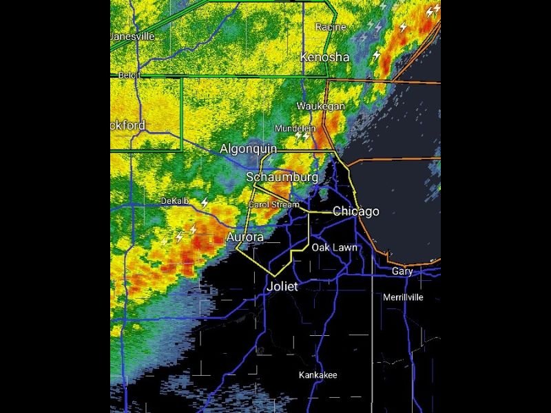
Warning Zone Covers Schaumburg, Carol Stream, Aurora, and Chicago
Radar at 10:17 PM shows active warning polygons covering a significant portion of the northeastern Illinois metro. The warned zone includes Schaumburg, Carol Stream, Aurora, Chicago, and Oak Lawn, with the storm line actively pushing through these communities during the update window.
Areas including Algonquin, Mundelein, and Waukegan to the north are also within the active impact zone, with the line extending northward into Kenosha and Racine across the Wisconsin state line. Lightning remains present but scattered compared to previous hours.
Storm Line Continues to Weaken as It Pushes East
The overall weakening trend that began earlier in the evening continues as of the 10:17 PM update. Lightning activity embedded within the storms is noticeably reduced compared to the previous night’s activity, and storm intensity on radar has diminished significantly from earlier in the evening.
Despite the weakening trend, forecasters are reminding residents that the outflow winds ahead of the line remain the primary concern and should not be underestimated simply because the storms themselves are losing intensity.
Joliet and Kankakee Still Ahead of the Line
As of 10:17 PM, communities south of the primary storm axis including Joliet and Kankakee remain just ahead of the arriving line. Residents in those areas should expect the outflow winds and rain to arrive shortly, with the brief but gusty wind threat being the primary concern as the weakening system pushes through.
The line is expected to clear the region through the overnight hours, with conditions gradually improving behind the departing system as the night progresses. Stay with NapervilleLocal.com for the latest weather updates and local forecast coverage.

I’ve lived in Naperville long enough to see how quickly our community changes — from new developments downtown to sudden shifts in our Midwest weather. Reporting on Naperville news and daily forecasts gives me the chance to keep neighbors informed about what really matters. My goal is simple: deliver clear, timely updates so you always know what’s happening in our city and what to expect from the skies above.