
Kansas to Chicago Facing Significant Wind Threat Today With 60-90 MPH Gusts and Embedded EF2+ Tornadoes Possible From Great Plains Into Upper Midwest
CENTRAL GREAT PLAINS TO UPPER MIDWEST — A significant and dangerous wind threat is unfolding today across a massive corridor stretching from the central Great Plains into the Upper Midwest as numerous severe storms are expected to organize into a powerful squall line by this evening. Damaging winds of 60 to 90-plus MPH will become the dominant hazard by tonight, with embedded tornadoes including potentially strong EF2 or greater events also remaining possible along the leading edge of the storm system.
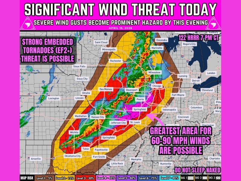
Storms Organize Into Squall Line Through the Afternoon and Evening
The severe weather threat will evolve in distinct stages through the day. Initial storms will begin developing during the afternoon hours before rapidly organizing into a QLCS squall line during the late afternoon and evening period.
By evening into overnight, the fully organized line will push eastward with widespread damaging winds and embedded tornado threats along its leading edge. The core of the most intense wind threat is focused across a corridor from Kansas City and St. Louis northward through Springfield, Peoria, Davenport, Des Moines, and into the Chicago and Milwaukee metro areas.
60 to 90 MPH Wind Gusts Are the Primary Hazard
The most widespread and significant threat with tonight’s squall line is the damaging wind potential. Storms will grow into a QLCS with bowing segments and surges capable of producing focused swaths of intense wind gusts reaching 75 to 90 MPH from Kansas into Missouri and northward.
The greatest area for 60 to 90 MPH winds as shown on the threat map covers a broad corridor including Kansas City, Jefferson City, St. Louis, Springfield IL, Peoria, Davenport, Des Moines, and Chicago. Wind gusts of this magnitude are capable of widespread tree damage, downed power lines, structural damage, and dangerous travel conditions.
Embedded EF2+ Tornadoes Possible Along the Line
Beyond the wind threat, embedded tornadoes represent a serious additional hazard with tonight’s squall line. QLCS mesovortices along the leading edge of the line are capable of producing brief but intense tornado spin-ups, with the threat map explicitly noting that strong embedded tornadoes of EF2 intensity or greater are possible.
These quick spin-up tornadoes associated with squall lines are particularly dangerous because they develop rapidly, provide little lead time for warnings, and can produce significant damage in a very short window. Residents across the entire threat corridor should have shelter plans ready well before the line arrives.
Threat Corridor Stretches From Oklahoma Through the Great Lakes
The risk map shows the most intense threat zone centered across a corridor from Oklahoma and Kansas northward through Missouri, Iowa, Illinois, and Wisconsin. Cities including Tulsa, Wichita, Oklahoma City, Kansas City, Des Moines, Davenport, Chicago, Milwaukee, and Rochester all fall within elevated risk categories on the map.
The outer risk zones extend further east toward Indianapolis, Detroit, and Cleveland, indicating that the broader severe weather footprint will be felt across a very large portion of the central and eastern United States through the overnight hours.
Be Ready Well Before the Line Arrives Tonight
Forecasters are urging all residents across the threat corridor to be fully prepared before the squall line arrives in their area this evening and overnight. Have multiple ways to receive weather alerts active, identify an interior shelter location on the lowest floor of a sturdy building, and do not wait for a warning to be issued before taking precautionary action.
Quick spin-up tornadoes along squall lines can produce warnings with very little lead time. Being sheltered and alert before the line arrives is the safest approach given tonight’s dangerous setup. Stay with NapervilleLocal.com for the latest weather updates and local forecast coverage.

I’ve lived in Naperville long enough to see how quickly our community changes — from new developments downtown to sudden shifts in our Midwest weather. Reporting on Naperville news and daily forecasts gives me the chance to keep neighbors informed about what really matters. My goal is simple: deliver clear, timely updates so you always know what’s happening in our city and what to expect from the skies above.