
Arkansas Hits Summer-Like Highs in the Mid to Upper 80s Friday Before Cold Front Arrives Tonight With Severe Weather Possible Across Northwest Arkansas
ARKANSAS — A warm and summer-like Friday afternoon is unfolding across Arkansas as temperatures push easily into the 80s statewide. The warmth will be short-lived however, as a cold front is inbound tonight that will drop temperatures significantly by tomorrow afternoon. Severe weather is also possible across northwest Arkansas late tonight ahead of the frontal passage, making this a day that starts warm and pleasant but ends with an active weather threat.
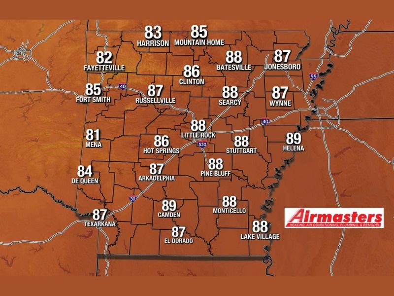
Statewide Highs Push Deep Into the 80s Friday Afternoon
Temperature data for Friday shows widespread upper 80s dominating the forecast map from corner to corner across Arkansas. Helena leads the state with a high of 89°F, followed closely by Camden and Stuttgart also reaching 89°F and 88°F respectively.
Little Rock, Batesville, Searcy, Pine Bluff, Monticello, and Lake Village are all forecast to hit 88°F. Central and western communities including Russellville, Arkadelphia, Texarkana, and El Dorado will reach the mid to upper 80s as well. Even the cooler northwest corner of the state sees Fayetteville reaching 82°F and Harrison hitting 83°F, keeping the entire state well above seasonal norms for the afternoon.
Northwest Arkansas Faces Severe Weather Risk Late Tonight
While the afternoon remains warm and dry across most of the state, the story changes significantly after dark. Some severe weather is possible across northwest Arkansas late tonight as the approaching cold front interacts with the warm and unstable air currently in place across the region.
Details on the exact timing and nature of the severe threat are still being refined as additional data becomes available through the morning. Residents across the Fayetteville, Fort Smith, and surrounding northwest Arkansas communities should monitor updated forecasts closely heading into the evening hours.
Cold Front Arrives Tonight Bringing Dramatic Temperature Drop
Behind the severe weather threat, the cold front itself will sweep through Arkansas tonight and usher in a dramatically different air mass by Saturday afternoon. Temperatures that are comfortably sitting in the mid to upper 80s on Friday will drop significantly by tomorrow, marking a sharp end to the brief summer preview the state is currently experiencing.
The front will also bring rain chances to additional portions of the state beyond the northwest severe weather zone, with more details on those rain opportunities expected to be released as the morning progresses and forecasters gather additional data.
Enjoy the Warmth but Prepare for What Follows Tonight
Friday afternoon offers some of the most summer-like conditions Arkansas has seen in recent weeks, with abundant warmth and plenty of opportunity for outdoor activities during the daylight hours. However, residents — particularly those in northwest Arkansas — should not lose sight of what is coming after dark.
Have a weather plan ready before tonight, ensure multiple ways to receive alerts are active, and stay tuned for updated information on both the severe weather timing and the cold front’s expected rain chances across the state. Stay with NapervilleLocal.com for the latest weather updates and local forecast coverage.

I’ve lived in Naperville long enough to see how quickly our community changes — from new developments downtown to sudden shifts in our Midwest weather. Reporting on Naperville news and daily forecasts gives me the chance to keep neighbors informed about what really matters. My goal is simple: deliver clear, timely updates so you always know what’s happening in our city and what to expect from the skies above.