
Tornadoes, Baseball-Size Hail, and 70 MPH Winds Threatening Rockford, Galena, and Stateline Region This Afternoon With All Modes of Severe Weather Possible 4-9 PM
STATELINE REGION, ILLINOIS — The severe weather threat for the Stateline region has not changed and is now coming into sharper focus for later today and tonight. The greatest threat window runs from 4 to 9 PM, with all modes of severe weather in play including tornadoes, large hail, damaging winds, and flooding. The Enhanced Risk zone covers the western Stateline corridor while a Slight Risk extends eastward through the Chicago metro and toward South Bend.
Precise Storm Timing by Community
Forecasters have broken down the storm arrival times by specific communities across the region. The first wave arrives approximately 4 to 7 PM across Galena, Savanna, Stockton, Mt. Carroll, Sterling, Rock Falls, and Lena.
The 5 to 8 PM window then impacts Forreston, Pearl City, Freeport, Dixon, Oregon, Mt. Morris, Amboy, German Valley, Pecatonica, Monroe, and New Glarus. The 6 to 9 PM window brings the threat to Rockford, Loves Park, Machesney Park, Roscoe, Rockton, South Beloit, Byron, Davis Junction, Rochelle, Ashton, Beloit, Janesville, Belvidere, Poplar Grove, DeKalb, Sycamore, and Harvard.
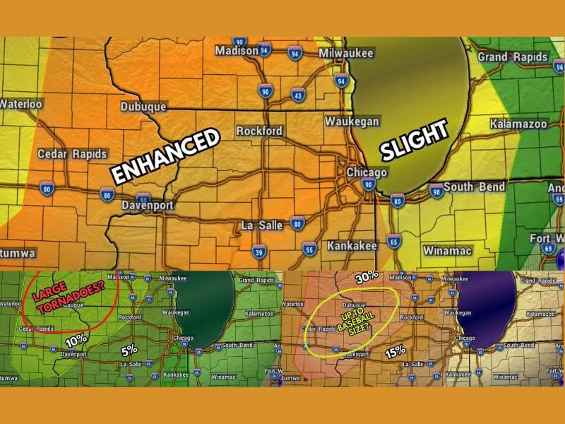
All Four Modes of Severe Weather in Play
Today’s setup is particularly dangerous because it involves every major category of severe weather simultaneously. Tornadoes are possible approximately 4 to 6:30 PM, concentrated across the western Stateline corridor where the Enhanced Risk is most intense.
Large hail up to baseball size carries a 30% probability and remains possible from approximately 4 to 7:30 PM. Damaging wind gusts exceeding 70 MPH carry a 45% probability across the highest risk zone and remain possible through the full 4 to 9 PM window. Flooding rounds out the threat, with that hazard extending the longest from 4 PM all the way through midnight.
Wild Card Threat Before 4 PM for NW Illinois and SW Wisconsin
Forecasters are flagging a significant wild card scenario for areas in far northwest Illinois, northeast Iowa, and southwest Wisconsin. Any isolated storms that develop before the main line arrives — prior to 4 PM — will be prime candidates to produce very large to giant hail and strong tornadoes.
This pre-line storm threat is particularly concerning because these isolated supercells would have access to the full unstable air mass before the squall line disrupts the environment. Residents in those areas need to be weather-aware starting well before the 4 PM primary window opens.
Enhanced Risk Covers Western Stateline, Slight Risk Extends to Chicago
The Severe Weather Risk map places the western Stateline corridor including Dubuque, Rockford, and surrounding areas under an Enhanced Risk for this afternoon and evening. The Slight Risk zone extends eastward covering Waukegan, Chicago, South Bend, Kankakee, and La Salle.
The tornado probability sits at 10% across the Enhanced zone and drops to 5% across the Slight Risk area near Chicago. Wind gusts exceeding 70 MPH carry a 45% probability in the highest risk zone, dropping to 0% across the eastern Slight Risk corridor.
Prepare Now Before the 4 PM Window Opens
With the storm clock ticking toward the 4 PM onset, residents across the entire Stateline region should finalize all severe weather preparations immediately. Identify shelter locations, charge devices, and have multiple ways to receive alerts active well before the first storms arrive.
The combination of tornadoes, giant hail, 70-plus MPH winds, and flooding through midnight makes this one of the more comprehensive severe weather setups the region has seen, and complacency is not an option heading into this afternoon and evening. Stay with NapervilleLocal.com for the latest weather updates and local forecast coverage.

I’ve lived in Naperville long enough to see how quickly our community changes — from new developments downtown to sudden shifts in our Midwest weather. Reporting on Naperville news and daily forecasts gives me the chance to keep neighbors informed about what really matters. My goal is simple: deliver clear, timely updates so you always know what’s happening in our city and what to expect from the skies above.