
Several Tornadoes and 75 MPH Destructive Winds Probable Across Eastern Iowa, Northern Illinois, and Central Wisconsin Today From Noon to 9 PM
EASTERN IOWA, NORTHERN ILLINOIS, AND CENTRAL WISCONSIN — A significant and dangerous severe weather outbreak is unfolding today across a broad corridor of the upper Midwest, with several tornadoes including one or two strong ones and destructive wind gusts up to 75 MPH probable from noon through approximately 9 PM.
The greatest area of tornado potential is focused across far eastern Iowa, northern Illinois, and central and southern Wisconsin, where the atmospheric setup is most favorable for organized and long-tracked tornado development.
Numerous Tornado Threat Zone Covers Illinois and Wisconsin Core
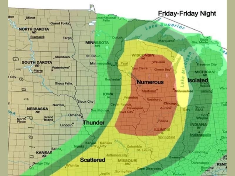
The outlook map places a Numerous tornado threat across the core zone covering northern Illinois, central and southern Wisconsin, and portions of eastern Iowa. This designation indicates that multiple tornadoes are not just possible but probable across this corridor during the noon to 9 PM window.
Cities including Rockford, Aurora, Chicago, Davenport, Iowa City, Cedar Rapids, Madison, Milwaukee, Green Bay, Eau Claire, and Wausau all fall within or near the Numerous threat zone. Residents across this entire corridor should be fully sheltered and prepared well before noon today.
One or Two Strong Tornadoes Possible Within the Outbreak
Beyond the general tornado threat, forecasters are specifically highlighting the potential for one or two strong tornadoes within today’s outbreak. Strong tornadoes carry the potential for significant and widespread damage across any community in their path, making today’s setup particularly concerning for the densely populated areas across northern Illinois and southern Wisconsin.
The combination of instability, wind shear, and favorable atmospheric dynamics across the core threat zone creates an environment capable of sustaining organized and long-tracked tornado activity through much of the afternoon and early evening hours.
Destructive Wind Gusts Up to 75 MPH Widespread Across the Region
Alongside the tornado threat, destructive straight-line wind gusts reaching up to 75 MPH are probable across a wide swath of the region from noon through 9 PM. The Scattered and Thunder zones extend well westward into Iowa, Nebraska, and Kansas, indicating that the damaging wind threat covers an enormous geographic footprint beyond just the core outbreak zone.
These wind gusts are capable of downing large trees, destroying power lines, causing structural damage, and creating extremely dangerous travel conditions across the affected corridor throughout the afternoon and evening.
Scattered and Thunder Zones Extend Into Iowa, Missouri, and Minnesota
Surrounding the core Numerous zone, a Scattered severe weather threat extends through much of Iowa, Missouri, and into southern Minnesota. An outer Thunder zone covers additional areas including Nebraska, Kansas, and portions of the Dakotas, indicating that the overall severe weather footprint today stretches across a massive portion of the central United States.
Even areas in the outer zones should not dismiss today’s threat, as isolated severe storms capable of large hail and damaging winds can develop anywhere within the broader risk area during the noon to 9 PM window.
Take Shelter Before Noon and Stay Alert Through 9 PM
With the threat window opening at noon, time is extremely limited for residents across eastern Iowa, northern Illinois, and central Wisconsin to finalize preparations. Shelter locations should be identified now, multiple alert systems should be active, and any outdoor plans for this afternoon and evening should be cancelled entirely.
Do not wait for a warning to be issued before moving to shelter. The speed at which tornadoes can develop during an active outbreak means that being proactive rather than reactive is the only safe approach for today’s dangerous setup. Stay with NapervilleLocal.com for the latest weather updates and local forecast coverage.

I’ve lived in Naperville long enough to see how quickly our community changes — from new developments downtown to sudden shifts in our Midwest weather. Reporting on Naperville news and daily forecasts gives me the chance to keep neighbors informed about what really matters. My goal is simple: deliver clear, timely updates so you always know what’s happening in our city and what to expect from the skies above.