
Severe Weather and Tornado Threat Returns to Southern Plains and Midwest Thursday Through Friday With Kansas, Oklahoma, and Arkansas in the Crosshairs
SOUTHERN PLAINS AND MIDWEST — After a brief pause in the relentless severe weather pattern that has gripped the central United States, the threat is returning Thursday through Friday and potentially beyond as a trough-ridge pattern develops across the country during peak storm season. Long-range models are consistently showing the southern Plains waking up again for severe weather and tornado potential through the end of April, with two distinct threat areas already outlined for Thursday and Friday.
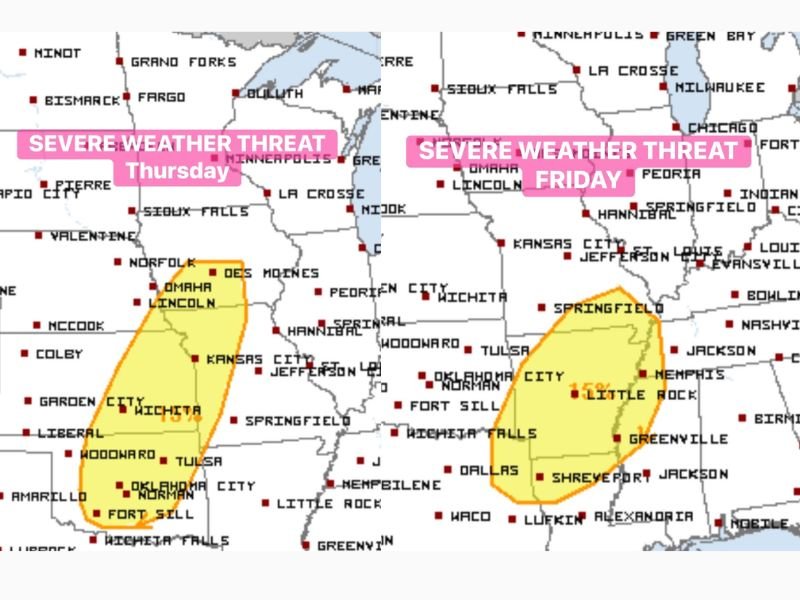
Two Separate Threat Areas Identified for Thursday and Friday
The outlook maps show two clearly defined severe weather threat zones developing across consecutive days this week. Thursday’s threat area is centered across Nebraska, Iowa, Kansas, and Missouri, with the risk zone stretching from Omaha and Lincoln southward through Kansas City, Wichita, and into the Oklahoma and Texas Panhandle region.
Friday’s threat area then shifts eastward, with the risk zone repositioning across Oklahoma, Arkansas, Texas, and into the mid-Mississippi Valley corridor including areas near Oklahoma City, Tulsa, Little Rock, Shreveport, and Memphis. The eastward shift of the Friday threat is consistent with the typical progression of trough-driven severe weather setups across the Plains.
Southern Plains Tornado Potential Increasing Through End of April
Beyond the immediate Thursday and Friday threat, long-range models are painting a concerning picture for severe weather and tornado potential across the southern Plains through the remainder of April. The developing trough-ridge pattern across the US is a classic setup for repeated and organized severe weather outbreaks during peak storm season.
The southern Plains including Oklahoma, Kansas, and surrounding states have been identified as the focal point for this extended severe weather and tornado potential. Residents across these states should remain on elevated alert not just for this week but through the end of the month as the active pattern continues to evolve.
Thursday Threat Centers on Nebraska, Iowa, Kansas, and Missouri
The Thursday severe weather area covers a broad swath of the central Plains from Nebraska and Iowa southward through Kansas and Missouri. Communities including Omaha, Lincoln, Des Moines, Kansas City, Wichita, Tulsa, and surrounding areas fall within or near the outlined risk zone for Thursday.
The setup for Thursday involves the leading edge of the trough interacting with increasingly unstable air across the central Plains, creating conditions favorable for organized severe storm development during the afternoon and evening hours.
Friday Threat Shifts Eastward Into Oklahoma and Arkansas
As the weather system progresses eastward through the week, Friday’s severe weather threat repositions across Oklahoma, Arkansas, Texas, and the mid-Mississippi Valley. Oklahoma City, Norman, Fort Sill, Wichita Falls, Dallas, Little Rock, Shreveport, Memphis, and Greenville all fall within or near the Friday risk zone.
The tornado potential on Friday appears particularly noteworthy given the southward extension of the risk area into Texas and Arkansas, where Gulf moisture and favorable wind shear will be in place to support rotating storms during the afternoon and evening hours.
Prepare Now for an Extended Period of Severe Weather
With severe weather threats now outlined for Thursday, Friday, and potentially beyond through the end of April, residents across the southern Plains and Midwest should treat this as an extended preparedness situation rather than a single-event threat. Ensure weather alert systems are active, identify shelter locations, and stay tuned to updated forecasts as each system approaches through the remainder of the week. Stay with NapervilleLocal.com for the latest weather updates and local forecast coverage.

I’ve lived in Naperville long enough to see how quickly our community changes — from new developments downtown to sudden shifts in our Midwest weather. Reporting on Naperville news and daily forecasts gives me the chance to keep neighbors informed about what really matters. My goal is simple: deliver clear, timely updates so you always know what’s happening in our city and what to expect from the skies above.