
Strong Tornadoes, Baseball-Size Hail, and 65 MPH Winds Threatening Eastern Kansas, Wichita, and Northern Oklahoma This Afternoon Through Overnight April 23
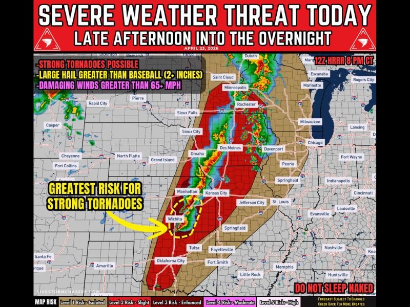
EASTERN KANSAS AND NORTHERN OKLAHOMA — A significant severe weather outbreak is unfolding today April 23, 2026 across the central Plains into the Upper Midwest, with the greatest concern focused on eastern Kansas into far northern Oklahoma where conditions are most favorable for strong tornadoes, very large hail of 2 to 3 inches or greater, and damaging winds exceeding 65 MPH.
The threat develops this afternoon along the cold front in Kansas, intensifies during the late afternoon and evening near the Kansas-Oklahoma border, and then spreads into northeast Oklahoma and southwest Missouri overnight as storms organize into clusters with embedded tornado risk.
Greatest Tornado Risk Centered Near Wichita and Kansas-Oklahoma Border
The threat map for April 23 clearly identifies the area near Wichita and the Kansas-Oklahoma border as the zone of greatest concern for strong tornadoes. A dashed yellow oval on the map highlights this core tornado risk zone, where a triple point setup will allow storms to become powerful supercells capable of very large hail and significant tornado development during the late afternoon and evening hours.
Strong tornado potential near the KS-OK border is explicitly flagged as the highest priority threat of the entire event, with storms in this zone potentially producing tornadoes that could be rated EF-2 or stronger if they develop and track through populated areas.
Storm Timeline Runs From Afternoon Through Overnight
The severe weather event follows a clear three-phase timeline across the region. During the afternoon, storms develop along the cold front in Kansas with initial supercell potential. The late afternoon through evening window then brings supercells with very large hail and increasing tornado potential, particularly near the Kansas-Oklahoma border.
By evening into overnight, storms organize and spread into northeast Oklahoma and southwest Missouri with a damaging wind and embedded tornado risk as the system transitions from discrete supercells into organized clusters moving southeast through the region.
Very Large Hail and 65 MPH Winds Threaten Broad Corridor
Across the broader risk corridor from Minnesota and Iowa through Kansas, mixed storm modes will produce hail, wind, and a couple of tornadoes along the front. The 12Z HRRR model valid at 8 PM CT shows an expansive red risk zone blanketing Iowa, Nebraska, Kansas, Missouri, and into Oklahoma, with the highest risk concentrations centered across the Omaha, Des Moines, Kansas City, Wichita, and Tulsa corridors.
Very large hail greater than 2 inches is expected especially with initial supercells, while damaging winds greater than 65 MPH become increasingly likely as storms grow upscale into organized clusters through the overnight hours across the region.
Oklahoma Dryline Adds Additional Uncertainty
Additional storm development along the Oklahoma dryline adds another layer of uncertainty to tonight’s setup. While development along the dryline is not certain, any storm that does form could produce very large hail and a tornado threat, potentially extending the severe weather footprint further south and west into Oklahoma beyond the primary risk corridor already outlined.
Residents across eastern Kansas, Wichita, northern Oklahoma, Iowa, and southwest Missouri should be fully sheltered and weather alert systems active well before the afternoon storm window opens today. Stay with NapervilleLocal.com for the latest weather updates and local forecast coverage.

I’ve lived in Naperville long enough to see how quickly our community changes — from new developments downtown to sudden shifts in our Midwest weather. Reporting on Naperville news and daily forecasts gives me the chance to keep neighbors informed about what really matters. My goal is simple: deliver clear, timely updates so you always know what’s happening in our city and what to expect from the skies above.