
All Modes of Severe Weather Possible Across Rockford, Dubuque, and Cedar Rapids Monday Into Monday Night as SPC Places Region Under Level 3 Enhanced Risk at 30%
NORTHERN ILLINOIS AND IOWA — Growing concern is emerging for a significant severe weather threat late Monday afternoon into Monday night across northern Illinois and Iowa, with the Storm Prediction Center already placing the region under a Level 3 Enhanced Risk at 30% probability for the Monday and Monday night period.
A vigorous upper level disturbance is expected to kick off widespread showers and thunderstorms across much of the Midwest during Monday afternoon and evening, with all modes of severe weather potentially in play including tornadoes, damaging winds, and large hail.
Level 3 Enhanced Risk at 30% Already Issued for Monday
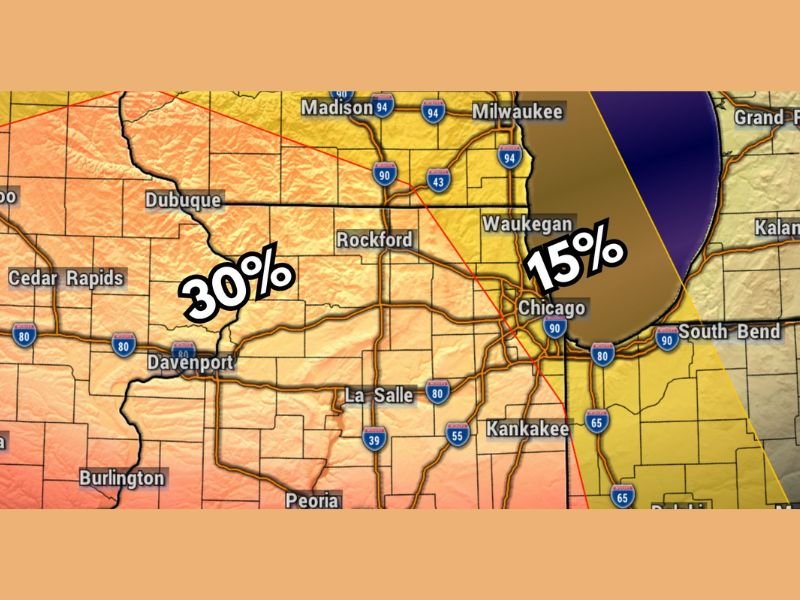
The SPC has already designated a 30% severe weather probability covering the northern Illinois and Iowa corridor for the Monday and Monday night period, equating to a Level 3 Enhanced Risk out of 5. The risk map shows the 30% zone centered across the Iowa and northern Illinois corridor including Dubuque, Rockford, Cedar Rapids, Waterloo, and Davenport, with a 15% Slight Risk zone extending eastward through the Chicago, Waukegan, and Milwaukee corridor.
The early issuance of a Level 3 risk several days out is a signal that forecasters have elevated confidence in the overall big picture setup for Monday, even if the precise details of timing and storm mode remain uncertain at this stage.
Vigorous Upper Level Disturbance Triggers Monday’s Threat
The driving force behind Monday’s severe weather potential is a vigorous upper level disturbance expected to sweep across the Midwest during the afternoon and evening hours. This type of upper level feature provides the dynamic lift needed to initiate and sustain widespread thunderstorm development across a large geographic area, particularly when combined with the instability and moisture expected to be in place across the region by Monday.
The combination of this upper level forcing with surface boundaries and increasing moisture through the weekend creates an environment that forecasters are watching with increasing concern heading into next week.
All Modes of Severe Weather Potentially in Play
Monday’s setup carries the potential for all modes of significant severe weather across the Enhanced Risk corridor. Tornadoes, large hail, and damaging winds are all considered possible during the Monday afternoon and evening window, making this a multi-hazard event rather than a single-threat situation.
The exact storm mode that dominates Monday’s event will depend on how the atmosphere evolves through the weekend, including the influence of prior storm activity and the positioning of surface boundaries heading into the Monday storm window.
Too Early for Precise Details but Preparation Should Begin Now
While specific timing and impact details remain uncertain given the several-day lead time, the consistency of the data in showing an elevated severe weather setup for Monday warrants early awareness and preparation across northern Illinois and Iowa. Residents across Rockford, Dubuque, Cedar Rapids, Waterloo, Davenport, and surrounding communities should monitor updated forecasts daily as the Monday threat comes into sharper focus through the weekend. Stay with NapervilleLocal.com for the latest weather updates and local forecast coverage.

I’ve lived in Naperville long enough to see how quickly our community changes — from new developments downtown to sudden shifts in our Midwest weather. Reporting on Naperville news and daily forecasts gives me the chance to keep neighbors informed about what really matters. My goal is simple: deliver clear, timely updates so you always know what’s happening in our city and what to expect from the skies above.