
Strong Tornadoes, Powerful Winds, and Very Large Hail Threatening Iowa, Illinois, and Missouri in Severe Weather Outbreak Monday Through Monday Night
IOWA, ILLINOIS, AND MISSOURI — A severe weather outbreak is increasingly likely next Monday through Monday night across a large portion of the Midwest, with the threat corridor now pushing further northwest than earlier anticipated. A strong shortwave trough will overspread a moist and unstable warm sector early Monday, with storms likely initiating early in the day across the region. Scattered supercells and line segments will pose an all-hazard risk including strong tornadoes, powerful winds, and very large hail across a broad zone centered over Iowa, Illinois, and Missouri.
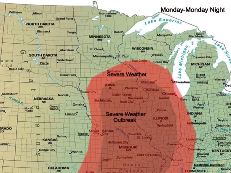
Severe Weather Outbreak Zone Covers Iowa Through Missouri and Illinois
The Monday through Monday night outlook map shows a large and concerning red Severe Weather Outbreak zone centered across Iowa, Illinois, and Missouri. The core outbreak area covers Des Moines, Cedar Rapids, Davenport, Iowa City, Waterloo, Sioux City, Rockford, Chicago, Aurora, Peoria, Springfield, St. Louis, Jefferson City, Kansas City, and Columbia among many other communities across the three-state corridor.
A broader Severe Weather zone extends outward from the outbreak core, reaching northward into Minnesota toward Rochester, Minneapolis, and St. Paul, and southward into Missouri toward Joplin, Springfield, and Cape Girardeau. The geographic scope of Monday’s threat is expansive and covers millions of residents across multiple states.
Storms Initiating Early Monday Pushes Risk Further Northwest
One of the most significant updates to Monday’s forecast is the earlier than anticipated storm initiation timing, which is now pushing the risk zone further northwest compared to earlier model guidance. Storms developing early in the day will have more time to organize and intensify before potentially transitioning into a squall line during the afternoon and evening hours.
This earlier timing also means that residents across the northwestern portions of the risk zone who may have previously felt they were on the outer edge of the threat area now face a more direct and meaningful severe weather risk heading into Monday.
All Hazard Risk Includes Strong Tornadoes and Very Large Hail
Monday’s outbreak setup carries an all-hazard severe weather profile across the outlined risk corridor. Strong tornadoes represent the most life-threatening concern, with scattered supercells during the early storm phase providing the most favorable environment for significant tornado development across Iowa and northern Illinois.
Very large hail capable of causing substantial property damage is expected particularly with the initial supercell activity before any squall line transition occurs. Powerful straight-line winds will then become increasingly dominant as storms organize into linear segments and push through the region during the afternoon and evening hours.
Begin Preparing Now for Monday’s Outbreak
With Monday’s severe weather outbreak growing increasingly likely and the risk zone expanding, residents across Iowa, Illinois, and Missouri should begin finalizing preparedness steps now rather than waiting until the weekend. Ensure weather alert systems are active, identify shelter locations, and monitor updated forecasts daily as Monday’s setup continues to come into sharper and more detailed focus through the weekend. Stay with NapervilleLocal.com for the latest weather updates and local forecast coverage.

I’ve lived in Naperville long enough to see how quickly our community changes — from new developments downtown to sudden shifts in our Midwest weather. Reporting on Naperville news and daily forecasts gives me the chance to keep neighbors informed about what really matters. My goal is simple: deliver clear, timely updates so you always know what’s happening in our city and what to expect from the skies above.