
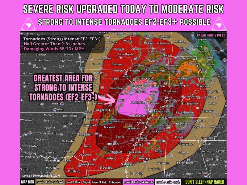
EF2 to EF3+ Tornadoes, 2 to 3 Inch Hail, and 70 MPH Winds Targeting Missouri and Illinois Including St. Louis and Springfield With Moderate Risk Upgraded Today
MISSOURI AND ILLINOIS — A dangerous tornado outbreak setup is developing across the mid Mississippi Valley into the lower Ohio Valley and Mid-South today, Monday, April 27, 2026, with the severe weather risk officially upgraded to Moderate Risk Level 4 of 5. Strong to intense tornadoes rated EF2 to EF3 and higher are expected, particularly from central Missouri into southern Illinois where the greatest area for violent tornado production is centered near St. Louis, Rolla, and Farmington. Storms are expected to develop between 2 and 5 PM CDT before spreading east and south through the evening and overnight hours.
Strong to Intense EF2 to EF3 Tornadoes Most Likely From Central Missouri Into Southern Illinois
The greatest concentration of tornado potential today sits across the corridor from central Missouri into southern Illinois, where an embedded Moderate Risk zone highlights the most dangerous outcomes. Conditions in this area will support intense supercells capable of producing multiple strong to intense tornadoes before storms eventually consolidate into clusters and lines later in the evening.
Storms are expected to initially remain discrete during the late afternoon window, which is when tornado potential will be at its maximum. The discrete supercell phase between late afternoon and early evening represents the most critical period for violent and long-track tornado production across Missouri and Illinois.
Widespread Damaging Winds Exceeding 70 MPH Expected as Storms Organize Into Lines
As storms grow upscale through the evening, they are expected to organize into clusters and squall lines producing widespread damaging wind gusts exceeding 70 miles per hour across a large portion of the affected region. This transition from discrete supercells to organized line segments will spread the damaging wind threat eastward into the lower Ohio Valley and Mid-South through the evening and overnight hours.
Wind gusts at this magnitude are capable of widespread tree and power line damage, structural impacts, and dangerous driving conditions across a broad corridor. Even communities outside the direct tornado threat zone face a significant damaging wind risk as the storm system evolves through tonight.
Large to Very Large Hail Up to 2 to 3 Inches Possible With Early Supercells
Large to very large hail measuring 2 to 3 inches or greater is possible with supercells during the early discrete phase of today’s storm event, particularly across the Missouri and Illinois corridor where storms remain most isolated. The hail threat diminishes somewhat as storms organize into lines later in the evening, shifting the primary hazard toward wind damage.
Residents across the affected area should move vehicles to covered locations before afternoon storms develop. Hail of 2 to 3 inches causes catastrophic vehicle and roof damage and can accumulate rapidly during prolonged supercell hail cores.
Tornado Threat May Extend South Into Arkansas and Tennessee Through the Night
As the storm system spreads southward through the evening and overnight hours, the tornado threat may extend into Arkansas and Tennessee, though confidence decreases somewhat with the southward extent of the risk. QLCS-embedded tornadoes remain possible as the line pushes through these areas later tonight.
This is an extremely dangerous setup and residents across the entire affected region must have multiple ways to receive warnings active before storms arrive. Do not rely on a single warning source during an event of this magnitude. Stay with NapervilleLocal.com for the latest weather updates and local forecast coverage.

I’ve lived in Naperville long enough to see how quickly our community changes — from new developments downtown to sudden shifts in our Midwest weather. Reporting on Naperville news and daily forecasts gives me the chance to keep neighbors informed about what really matters. My goal is simple: deliver clear, timely updates so you always know what’s happening in our city and what to expect from the skies above.