
Scattered Storms Wednesday With Wet Snow Possible Overnight Across Colorado Including Colorado Springs, Pueblo, and the Palmer Divide Before Major System Arrives Thursday
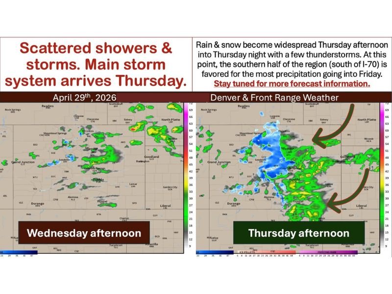
COLORADO AND FRONT RANGE — A cold front sliding in from the north this Wednesday, April 29, 2026, will trigger scattered showers and thunderstorms across a good portion of Colorado and the Front Range, moving from west to east through the afternoon and evening hours.
The more significant development comes late tonight into Thursday morning, when rain could mix with or change over to wet snow along and south of the Palmer Divide across areas including Colorado Springs, Teller County, El Paso County, Black Forest, and Woodland Park. A much larger and more widespread storm system then arrives Thursday afternoon into Thursday night, bringing widespread rain and snow across the region.
Cold Front Triggers Scattered Showers and Storms Wednesday Afternoon Into Evening
The incoming cold front will fire scattered showers and a few thunderstorms across a broad area of Colorado this afternoon, with the most consistent activity expected from the Denver corridor southward through Pueblo and into the southeastern plains. Winds will be breezy but not a major concern, with gusts of 25 to 35 miles per hour possible as the front moves through the region from west to east through the afternoon hours.
Hail is always a risk with stronger storms when cold air is present aloft, and that dynamic remains in play with today’s setup. Shower and storm activity will likely hang around through tonight into Thursday morning as the system continues to evolve ahead of the larger incoming storm.
Wet Snow Possible Late Tonight Along and South of Palmer Divide Through Thursday Morning
The most impactful development from today’s front arrives late tonight into Thursday morning, when colder air filtering in behind the front could cause rain to mix with or change over to wet snow along and south of the Palmer Divide. Areas being watched closely include Teller County, El Paso County, the south side of Douglas County, Woodland Park, Colorado Springs, Air Force Academy, Black Forest, Larkspur, and Monument.
Precipitation type will be elevation-dependent, with areas below 5,000 feet seeing mostly cold rain, elevations between 5,500 and 6,000 feet seeing rain transitioning to wet snow, and areas above that threshold expecting mainly wet snow. Residents in these zones should monitor conditions closely overnight as accumulations will depend on exact storm track and temperature trends.
Major Storm System Brings Widespread Rain and Snow Thursday Afternoon Into Friday
The main storm system arrives Thursday afternoon and is expected to bring widespread and more organized precipitation across the region through Thursday night and into Friday. An additional surge of northeasterly upslope flow Thursday will enhance precipitation coverage, with the southern half of the region south of Interstate 70 favored for the heaviest totals going into Friday.
Model consensus currently keeps the heaviest precipitation south of the I-70 corridor, with amounts tapering off northward into northeast Colorado, the Cheyenne Ridge, southeast Wyoming, and the Nebraska Panhandle. Storm track remains a key variable that could shift totals significantly, and forecast details will continue to be refined through Wednesday as the system approaches. Stay with NapervilleLocal.com for the latest weather updates and local forecast coverage.

I’ve lived in Naperville long enough to see how quickly our community changes — from new developments downtown to sudden shifts in our Midwest weather. Reporting on Naperville news and daily forecasts gives me the chance to keep neighbors informed about what really matters. My goal is simple: deliver clear, timely updates so you always know what’s happening in our city and what to expect from the skies above.