
Large Hail, Damaging Winds, and a Tornado Possible Across Central and West-Central Texas Including Austin, San Antonio, and Killeen With Several Severe Storms Expected This Afternoon
CENTRAL AND WEST-CENTRAL TEXAS — Severe storms are possible this afternoon and evening across central and west-central Texas into east Texas, with large hail as the headline threat and damaging winds and a tornado or two also on the table.
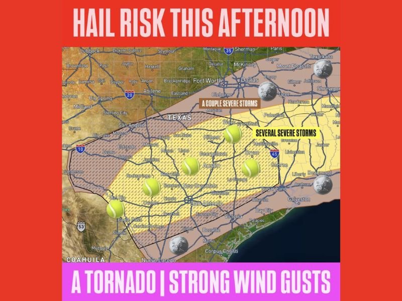
The outlook map shows a core zone of several severe storms covering the Austin, Killeen, San Antonio, and surrounding Hill Country corridor, with a broader outer zone of a couple of severe storms extending northward toward the Fort Worth, Waco, and Tyler areas. Residents across the affected region should remain weather aware through the afternoon and into the evening hours.
Large Hail Is the Primary Threat Across the Central Texas Core Zone
Tennis ball-size hail markers are displayed across a broad swath of the central Texas threat area, indicating a significant hail production potential with supercells that develop this afternoon across the Austin, Killeen, San Antonio, New Braunfels, and Hill Country corridor. Large hail of this magnitude causes catastrophic damage to vehicles, destroys roofing materials, and can injure anyone caught outdoors when stones begin falling.
All vehicles across the central Texas severe storm zone should be moved to covered parking before afternoon storms develop. The several severe storms designation for the core yellow zone indicates a higher probability of multiple hail-producing supercells tracking through this corridor during the peak afternoon heating hours.
Several Severe Storms Possible From Austin Through San Antonio Into East Texas
The innermost zone on today’s hail risk map covers the corridor from the Hill Country eastward through Austin, Georgetown, La Grange, Bryan, and into Madisonville and Conroe, where several severe storms are forecast. This designation reflects a meaningful and elevated probability of multiple organized severe storm events impacting this specific corridor through the afternoon and evening hours.
A broader outer zone covering areas from Abilene and San Angelo northward through Fort Worth and Dallas eastward to Tyler and Shreveport carries a couple of severe storms designation. Communities including Waco, Cleburne, Palestine, and surrounding areas should remain alert as supercells from the core zone could track into these areas through the evening hours.
Tornado and Strong Wind Gusts Round Out the Hazard Profile This Afternoon
A tornado or two are possible with today’s severe storm setup, adding a significant dimension to the overall hazard profile beyond the dominant hail threat. Any supercell that develops across the central Texas core zone will have the atmospheric support needed to produce a brief or isolated tornado alongside its primary large hail threat.
Strong wind gusts also accompany today’s severe storm risk across the full extent of the threat area from west-central Texas through east Texas. Residents across Austin, San Antonio, Killeen, and surrounding communities should have multiple ways to receive warnings active before afternoon storms develop and be prepared to take shelter immediately if a warning is issued for their area. Stay with NapervilleLocal.com for the latest weather updates and local forecast coverage.

I’ve lived in Naperville long enough to see how quickly our community changes — from new developments downtown to sudden shifts in our Midwest weather. Reporting on Naperville news and daily forecasts gives me the chance to keep neighbors informed about what really matters. My goal is simple: deliver clear, timely updates so you always know what’s happening in our city and what to expect from the skies above.