
Frontal Line Storms With Tornado Mention Possible Across the Gulf Coast and Southeast Later Friday Into Saturday Morning With Marginal Risk in Place
GULF COAST AND SOUTHEAST — A lingering frontal boundary across the Gulf region is setting up a storm threat for the Gulf Coast and Southeast later this Friday into Saturday morning, May 1 into May 2, 2026. The SPC Day 3 categorical outlook issued April 29 places a Marginal Risk across a broad corridor from the central Gulf Coast eastward through the Florida panhandle and into portions of the Southeast. Tornadoes are mentioned as a possibility with this setup, particularly with areas developing off the Gulf as the frontal line builds and pushes eastward through the overnight period.
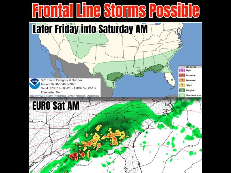
SPC Day 3 Outlook Places Marginal Risk From Gulf Coast Through the Southeast
The Storm Prediction Center’s Day 3 outlook valid from noon Friday May 1 through noon Saturday May 2 shows a Marginal Risk zone covering the central and eastern Gulf Coast region, with a broader thunderstorm coverage area extending across a wider footprint from the Southern Plains through the Mid-South and into the Southeast. The Marginal designation reflects a low but non-zero severe weather potential as the frontal boundary interacts with Gulf moisture through the Friday evening and overnight hours.
A secondary darker Marginal zone is visible near the central Gulf Coast where storm development off the Gulf is most likely and where the most organized storm activity is expected to occur during the overnight period. This coastal focus area warrants the closest monitoring as Gulf-fed convection can intensify rapidly when conditions align.
Tornado Mention Included in the Forecast for Friday Night Into Saturday Morning
The SPC has specifically mentioned tornadoes as a possibility with Friday night’s storm setup, a notable inclusion for what is currently a Marginal Risk event. Tornado potential with frontal line storms and Gulf-fed convection is typically brief and embedded within squall line segments, but these types of tornadoes can develop quickly and with limited warning time.
The Euro model for Saturday morning shows a concentrated line of storms with embedded heavier cores pushing eastward across the Gulf Coast region, providing a general picture of how the storm system could evolve overnight. Storm track and intensity details will become clearer as the event approaches later in the week.
Frontal Line Expected to Build and Push East Through the Friday Overnight Hours
The overall storm scenario for Friday night involves a frontal line building offshore and pushing eastward through the overnight hours into Saturday morning. This type of nocturnal frontal passage can produce widespread wind damage, heavy rainfall, and embedded severe weather across a broad geographic area as it moves through the region.
Residents across the Gulf Coast, Florida panhandle, and surrounding Southeast communities should monitor forecast updates through Friday as details on storm timing, track, and intensity continue to be refined. Having weather alerts active before going to bed Friday night is a reasonable precaution for anyone in the affected region. Stay with NapervilleLocal.com for the latest weather updates and local forecast coverage.

I’ve lived in Naperville long enough to see how quickly our community changes — from new developments downtown to sudden shifts in our Midwest weather. Reporting on Naperville news and daily forecasts gives me the chance to keep neighbors informed about what really matters. My goal is simple: deliver clear, timely updates so you always know what’s happening in our city and what to expect from the skies above.