
Damaging Wind Gusts, Hail, and Low Tornado Risk Possible Across the Carolinas and Georgia Including East of Charlotte This Wednesday Afternoon if Atmosphere Destabilizes
CAROLINAS AND GEORGIA — A conditional severe weather setup is in place across the Carolinas and Georgia this Wednesday afternoon, April 29, 2026, with the outcome heavily dependent on how much clearing occurs after this morning’s clouds and rain.
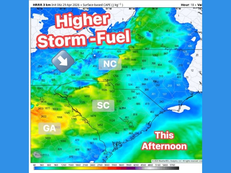
If temperatures manage to jump into the 80s through the afternoon, the atmosphere could recover and destabilize enough to support a few strong storms across the region. Not everyone will see storms today, but any that do develop could turn strong quickly given the elevated storm fuel values visible on HRRR surface-based CAPE data across South Carolina, North Carolina, and Georgia.
Afternoon Clearing Is the Key Trigger for Storm Development Across the Region
The entire severe weather scenario today hinges on whether enough clearing occurs after the morning rain to allow surface temperatures to surge into the 80s and destabilize the atmosphere. HRRR model data shows surface-based CAPE values ranging from roughly 1,400 to over 2,400 joules per kilogram across portions of South Carolina and Georgia, indicating substantial storm fuel is available if the atmosphere can tap into it through afternoon heating.
Western South Carolina and northern Georgia are showing the highest CAPE values on the afternoon map, suggesting those areas carry the greatest potential for storm development and intensity if clearing allows surface-based instability to build. The atmosphere is essentially loaded and waiting for the right trigger this afternoon.
Damaging Wind Gusts and Hail Are the Primary Threats With Any Strong Storm
Damaging wind gusts and hail are listed as the two primary hazards with any storms that develop across the Carolinas and Georgia this afternoon. These threats are consistent with the supercell and strong convective storm mode that would be expected given the instability and wind energy present in the atmosphere across the region today.
Storms that develop in high-CAPE environments with adequate wind shear can produce significant hail and destructive wind gusts rapidly after initiation. The conditional nature of today’s setup means hazards would be isolated rather than widespread, but individual storm impacts could still be significant in any community directly under a developing cell.
Low but Non-Zero Tornado Risk Highest East of Charlotte This Afternoon
A low but not zero tornado risk exists across the region today, with the highest tornado potential focused east of Charlotte where wind energy in the atmosphere is most favorable for rotation. While tornado development is not the primary concern with today’s setup, any storm producing rotation in a high-CAPE environment can quickly become dangerous.
Residents across the Carolinas and Georgia should treat this as a watch-the-sky afternoon and keep weather alerts active through the early evening hours. The conditional nature of today’s setup means the threat could either remain minimal or escalate quickly depending on how afternoon heating evolves across the region. Stay with NapervilleLocal.com for the latest weather updates and local forecast coverage.

I’ve lived in Naperville long enough to see how quickly our community changes — from new developments downtown to sudden shifts in our Midwest weather. Reporting on Naperville news and daily forecasts gives me the chance to keep neighbors informed about what really matters. My goal is simple: deliver clear, timely updates so you always know what’s happening in our city and what to expect from the skies above.