
Large Hail, Damaging Winds and Tornadoes Targeting Most of Arkansas Including Little Rock, Fort Smith, and Jonesboro Tuesday With Threat Lingering Into Wednesday Morning
ARKANSAS — Severe weather chances are returning to Arkansas on Tuesday, May 5, 2026, with most of the state falling inside the severe outlook zone for large hail, damaging winds, and a tornado threat if conditions align correctly. Tuesday is identified as the most concerning day of the event, though hazards could linger into Wednesday morning before the system exits the region. Better forecast details are expected to arrive over the next two days as the system comes into closer range.
Large Hail and Damaging Winds Are the Primary Hazards Across the Tuesday Risk Zone
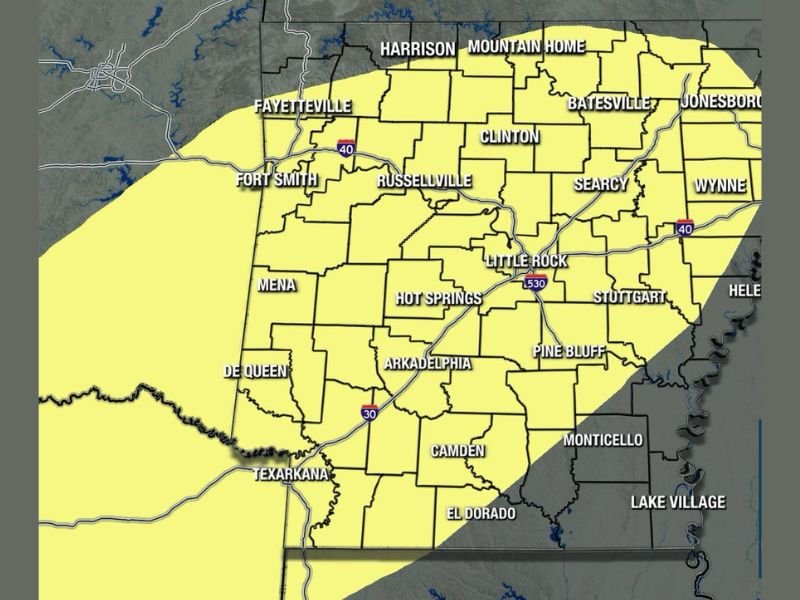
The Tuesday severe outlook covers the majority of Arkansas in a yellow zone running from Texarkana and Fort Smith through Little Rock, Russellville, Searcy, and Jonesboro across the central and eastern portions of the state. Large hail and strong damaging winds represent the main threats forecasters are monitoring most closely heading into Tuesday.
The risk level sits between low and medium across the outlined zone, reflecting increasing but not yet locked-in confidence in the severe weather setup. Most of the state will have an opportunity to see activity with this round, making statewide awareness necessary rather than just isolated pockets.
Tornadoes Cannot Be Ruled Out if Atmosphere Lines Up Correctly Tuesday
Beyond hail and wind, tornadoes remain a possibility across Arkansas on Tuesday if the atmospheric ingredients fall into place correctly. The combination of instability and wind shear associated with this system creates an environment where tornado development is plausible, particularly during the peak heating hours of Tuesday afternoon and evening.
Residents across the entire yellow zone from Fayetteville and Harrison through Hot Springs, Pine Bluff, and Helena should have weather alerts active and a shelter plan ready well ahead of Tuesday’s arrival.
Threat Could Linger Into Wednesday Morning Before System Exits the Region
While Tuesday carries the highest concern, the severe weather potential does not end at midnight. Hazards could persist into Wednesday morning as the system continues pushing through the region, extending the window of concern for communities across central and eastern Arkansas through the overnight hours. Stay with NapervilleLocal.com for the latest weather updates and local forecast coverage.

I’ve lived in Naperville long enough to see how quickly our community changes — from new developments downtown to sudden shifts in our Midwest weather. Reporting on Naperville news and daily forecasts gives me the chance to keep neighbors informed about what really matters. My goal is simple: deliver clear, timely updates so you always know what’s happening in our city and what to expect from the skies above.