
Heavy Rain 3 to 5 Inches, Damaging Winds, Hail and Tornado Threat Targeting Alabama Including Birmingham, Tuscaloosa and Huntsville Wednesday With Localized Flooding Likely
ALABAMA — Wednesday is shaping up as the impact day for Alabama, May 6, 2026, with a slow-moving and powerful storm system delivering heavy rain of 3 to 5 inches, damaging wind gusts, hail, and a limited tornado threat across the state. Rain and storms develop late Wednesday with the most intense activity pushing through Birmingham, Tuscaloosa, Huntsville, Gadsden, and Anniston by 11:30 PM based on future track modeling. Localized flooding is likely, especially across areas that already received over 4 inches of rain last week.
Heavy Rain of 3 to 5 Inches Headlines Wednesday Threat With Flooding Likely
The primary and most significant hazard on Wednesday is heavy rainfall in the 3 to 5 inch range across Alabama. Localized flooding is expected to be a serious concern, particularly across communities that received significant rainfall last week and where soils are already saturated.
Damaging wind gusts capable of knocking down trees and causing power outages are the secondary concern, most likely during the Wednesday night hours as the storm system pushes through.
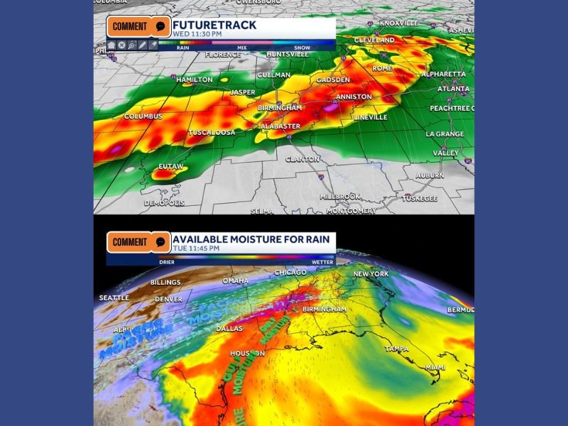
Future Track Shows Intense Storm Activity Pushing Through Birmingham by 11:30 PM
Future track modeling valid at 11:30 PM Wednesday shows intense red and orange radar returns pushing through Birmingham, Tuscaloosa, Alabaster, Jasper, Cullman, and Gadsden. The storm line is tracking northeast through the state during the late evening hours.
A rich plume of Gulf moisture feeding into Alabama is clearly visible on moisture analysis, providing ample fuel for heavy rainfall and storm intensity through the Wednesday night window.
Breezy and Warm Tuesday Before Drying Out Thursday and Beautiful Weekend Ahead
Tuesday stays warm and breezy with highs near 80 degrees and gusts over 25 mph ahead of the Wednesday system. Thursday brings lingering morning showers before drying out with a high near 70 degrees.
Friday turns sunny and warm at 72 degrees while Saturday delivers a beautiful and dry day with highs in the upper 70s. The positive side of Wednesday’s rain is meaningful drought recovery as soil moisture finally moves into positive range statewide. Stay with NapervilleLocal.com for the latest weather updates and local forecast coverage.

I’ve lived in Naperville long enough to see how quickly our community changes — from new developments downtown to sudden shifts in our Midwest weather. Reporting on Naperville news and daily forecasts gives me the chance to keep neighbors informed about what really matters. My goal is simple: deliver clear, timely updates so you always know what’s happening in our city and what to expect from the skies above.