
Strong Storm Line With Heavy Rain and Loud Thunder Sweeping From Louisiana and Shreveport Through New Orleans and Marching East Toward Jackson and Mississippi Saturday Morning
LOUISIANA AND GULF COAST — A strong and active storm line is moving through Louisiana and the broader Gulf Coast region Saturday morning, bringing heavy rain, loud thunder, and wet roads from the Shreveport corridor southward through New Orleans and pushing eastward toward Jackson and Mississippi.
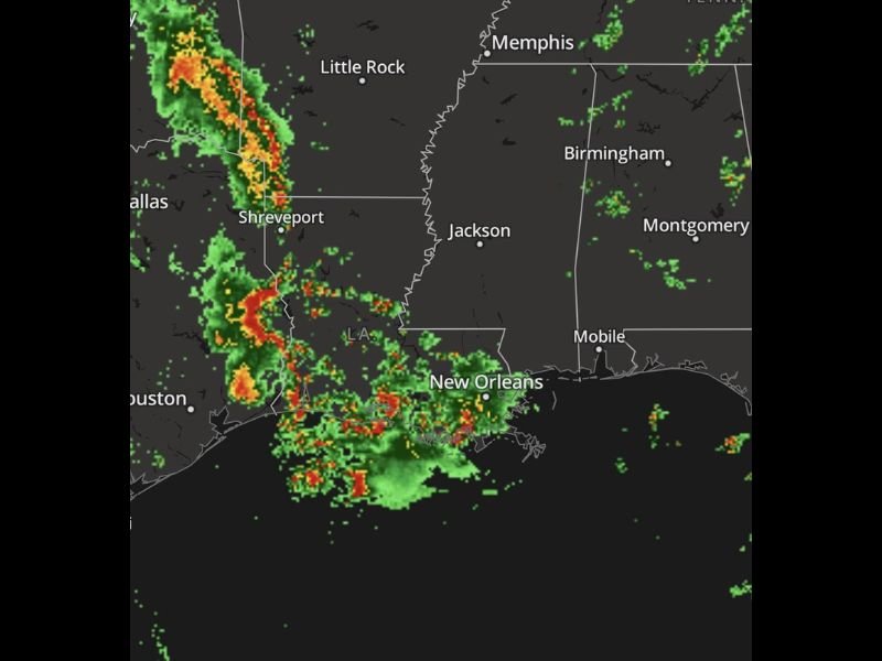
Radar shows intense red and yellow cores concentrated along a north-to-south oriented line stretching from near Dallas and Little Rock southward through Shreveport and into the New Orleans metro and Gulf Coast zones. Residents waking up to thunder this morning should not be alarmed but should remain indoors and stay weather aware as the line continues its eastward march.
Intense Storm Line Stretching From Shreveport Through New Orleans Saturday Morning
Radar imagery shows a well-defined and intense storm line with heavy red and yellow cores running from near Shreveport southward through Louisiana and into the New Orleans area Saturday morning. The most intense storm activity is concentrated along this north-to-south oriented line, with heavy rain rates and frequent lightning occurring within the strongest cells.
New Orleans is taking a direct hit from the heaviest portion of the line, with dense storm cores pressing directly into the metro area. Residents across New Orleans, Shreveport, and the surrounding Louisiana corridor should expect continued heavy rain and loud thunder through the morning hours as the line pushes through.
Storm System Marching Eastward Toward Jackson and Mississippi Through the Morning
The storm line is tracking eastward and will impact Jackson and broader Mississippi communities as the morning progresses. Mississippi is currently on the eastern edge of the active radar returns but will see increasing storm activity as the line advances across the state boundary through the coming hours.
Wet roads will be a significant concern across all areas as the line moves through, with heavy rain rates capable of reducing visibility and creating standing water on roadways. Residents in Jackson and surrounding Mississippi communities should prepare for storm impacts and avoid unnecessary travel while the line is actively moving through.
Heavy Rain, Loud Thunder, and Wet Roads the Primary Hazards Across the Gulf Coast Today
The main hazards associated with today’s storm line across Louisiana and Mississippi are heavy rainfall, loud and frequent thunder, and dangerously wet road conditions. While this event is not primarily a tornado or wind outbreak, the intensity and coverage of the rainfall and lightning make it a storm system that demands respect and indoor shelter during passage.
Anyone across the affected corridor from Houston and Dallas eastward through New Orleans and toward Birmingham and Mobile should remain weather aware through the morning and avoid any flooded roadways regardless of how passable they may appear. Stay with NapervilleLocal.com for the latest weather updates and local forecast coverage.

I’ve lived in Naperville long enough to see how quickly our community changes — from new developments downtown to sudden shifts in our Midwest weather. Reporting on Naperville news and daily forecasts gives me the chance to keep neighbors informed about what really matters. My goal is simple: deliver clear, timely updates so you always know what’s happening in our city and what to expect from the skies above.