
Long-Range Models Hinting at Highly Active Severe Weather Pattern Across the Central and Southern US Including Texas, the Plains, and Gulf Coast From June 5 Through June 12
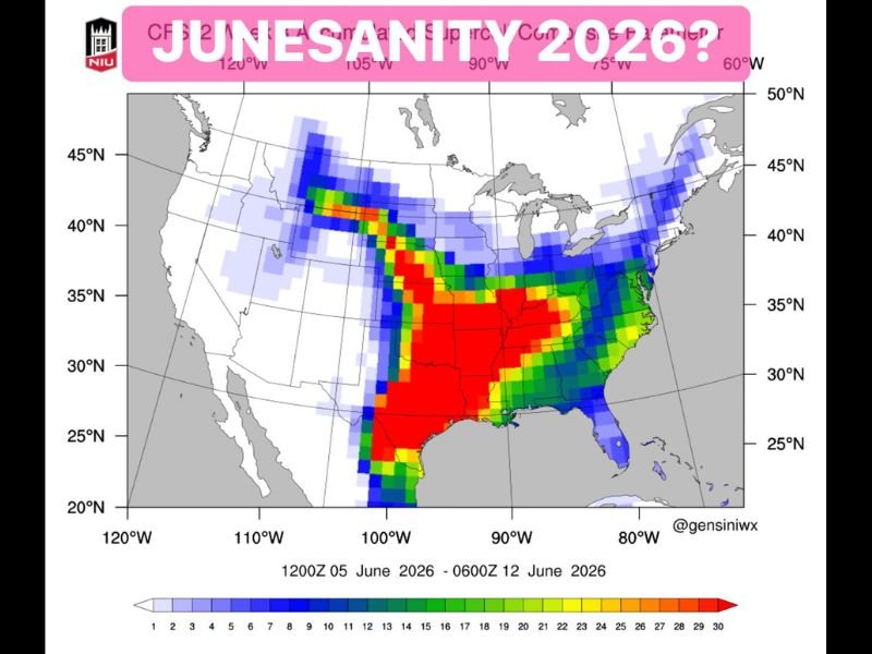
CENTRAL AND SOUTHERN UNITED STATES — Long-range models are signaling a potentially very active severe weather pattern across the central and southern United States during the June 5 through June 12, 2026 window, with CFS model output showing elevated severe weather parameter values concentrated heavily across Texas, the southern plains, and the Gulf Coast corridor.
The pattern being hinted at has drawn comparisons to what meteorologists call a high plains severe weather outbreak cycle, with the most intense signals centered across Texas and spreading northward through the central plains. Confidence remains low at this range but the signal is consistent enough to warrant early awareness.
CFS Model Showing Strongest Severe Weather Signal Centered Across Texas and Southern Plains
The CFS model valid from 1200Z June 5 through 0600Z June 12 shows the most intense severe weather parameter values concentrated across Texas and the southern plains, with deep red signatures covering virtually the entire state of Texas and extending northward through Oklahoma and into Kansas. These red values on the severity scale reach into the highest ranges depicted on the model output, suggesting a potentially significant severe weather setup during this period.
The signal extends southward all the way through southern Texas and into Mexico, while also pushing eastward through Louisiana and into the Mississippi Valley corridor. If this pattern verifies, Texas and the surrounding southern plains region would face an elevated and potentially significant severe weather threat during the June 5 to 12 window.
Active Severe Weather Arm Extends Northward Through the Plains Into the Upper Midwest
Beyond the Texas core, the model output shows an arm of elevated severe weather parameters extending northward through the central plains and into the upper Midwest around the 40 to 45 degree north latitude band. This northward extension suggests the potential for severe weather activity well beyond just the southern plains during the active June period.
The blue and green values across the northern tier indicate a broader but less intense severe weather signal extending from the central plains through portions of the Great Lakes region. This wide geographic footprint is consistent with what long-range models depict during active severe weather pattern cycles across the country.
Early Signal Only but Consistent Enough to Begin Monitoring for Late Early June Severe Threat
Forecasters are careful to note that long-range model output at this time range carries significant uncertainty, and the exact placement, timing, and intensity of any severe weather during June 5 to 12 remains very much to be determined. However, the consistency of the signal across multiple model runs makes it worth monitoring as the period approaches.
Residents across Texas, the southern and central plains, and the broader Gulf Coast corridor should begin paying attention to forecast updates as June approaches. Early awareness and preparedness are always the best tools when long-range models hint at a potentially active and significant severe weather period ahead. Stay with NapervilleLocal.com for the latest weather updates and local forecast coverage.

I’ve lived in Naperville long enough to see how quickly our community changes — from new developments downtown to sudden shifts in our Midwest weather. Reporting on Naperville news and daily forecasts gives me the chance to keep neighbors informed about what really matters. My goal is simple: deliver clear, timely updates so you always know what’s happening in our city and what to expect from the skies above.