
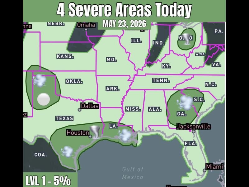
Four Separate Level 1 Severe Areas Active Across the Central and Eastern US Including Texas, Houston, Georgia, and Ohio With Wind and Hail Threats Saturday May 23
CENTRAL AND EASTERN UNITED STATES — Four distinct Level 1 severe weather areas are active across the country on Saturday, May 23, 2026, spanning from the Texas Panhandle through the Gulf Coast, Georgia and the Carolinas, and into Ohio. While no single area represents a major outbreak, each zone carries a 5 percent severe probability and residents across all four corridors need to remain weather-aware through the day.
Texas Panhandle Carrying the Most Concentrated Severe Risk With Wind and Hail Today
The Texas Panhandle region stands out as the most focused and concentrated severe area of the four zones on Saturday. High-based storms developing here will primarily capitalize on damaging wind and hail as the main hazard modes through the afternoon and evening hours.
The storm mode across the panhandle favors organized cells capable of producing large hail alongside severe wind gusts. Residents across the Texas Panhandle should protect vehicles and outdoor property before afternoon storm development begins.
Houston and Gulf Coast Zone Watching Tornado-Capable Storms Through Saturday
The Houston and broader Gulf Coast corridor represents a separate Level 1 severe zone with tornado-capable storm icons depicted across south Texas and into Louisiana on the severe areas map. This zone sits within the broader Gulf moisture feed and carries a real if low-probability severe threat through the day.
The combination of Gulf moisture and daytime instability gives storms developing in this corridor enough support to become organized and potentially severe. Residents from Houston through the Louisiana Gulf Coast should monitor conditions closely through the afternoon and evening.
Georgia Through the Carolinas and Ohio Round Out the Four Active Severe Zones
A third severe zone covers Georgia through portions of South Carolina near the Jacksonville corridor, where storm development carries a Level 1 severe risk through Saturday. The fourth and northernmost zone is positioned across Ohio, rounding out the four-zone severe weather picture for the day.
None of the four zones are expected to produce a major severe weather outbreak, but the multi-zone nature of today’s setup means a broad geographic area of the country needs to stay alert. Checking local forecasts and having a shelter plan ready is the recommended approach for residents across all four active severe areas Saturday. Stay with NapervilleLocal.com for the latest weather updates and local forecast coverage.

I’ve lived in Naperville long enough to see how quickly our community changes — from new developments downtown to sudden shifts in our Midwest weather. Reporting on Naperville news and daily forecasts gives me the chance to keep neighbors informed about what really matters. My goal is simple: deliver clear, timely updates so you always know what’s happening in our city and what to expect from the skies above.