
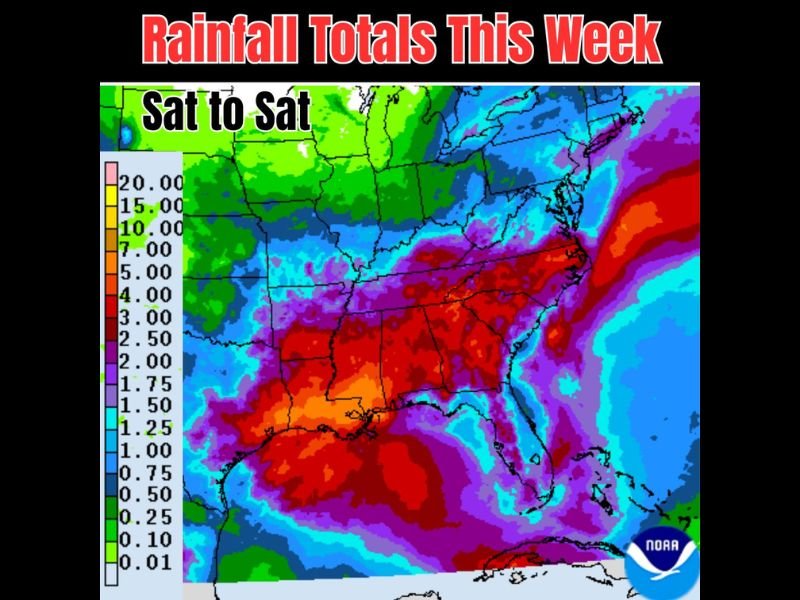
Heavy Rainfall Threat Targeting the Southeast and Eastern Seaboard From Texas Through the Carolinas With Isolated Pockets of Several Inches Possible Saturday Through Next Saturday
SOUTHEASTERN UNITED STATES — A significant weekly rainfall accumulation is forecast across the Southeast and Eastern Seaboard from this Saturday through next Saturday, May 30, as lowering pressures increase rain chances across a broad corridor. The NOAA rainfall total map shows widespread purple and red signatures indicating 3 to 5 or more inches across the Deep South, Gulf Coast, and up through the Carolinas and Mid-Atlantic, with some aggressive model solutions showing isolated pockets reaching several inches in localized spots.
Deep South and Gulf Coast Facing the Heaviest Weekly Rainfall Accumulations
The heaviest rainfall totals on the Saturday-to-Saturday forecast map are concentrated across the Deep South and Gulf Coast corridor, where widespread red signatures indicate accumulations of 4 to 5 or more inches across Louisiana, Mississippi, Alabama, and into Tennessee. The purple zones blanketing this region suggest totals of 3 to 4 inches will be common across a very wide area.
Texas also falls within the significant rainfall zone, with purple and red coverage extending across much of the state through the weekly period. These totals arriving on already-saturated ground across portions of the Gulf Coast region elevate the flood risk considerably through the coming week.
Carolinas and Mid-Atlantic Corridor Also Within Heavy Rainfall Zone Through the Week
The Carolinas and Mid-Atlantic coastline show some of the most intense rainfall signatures on the map, with deep red coverage pushing into the eastern Carolinas and along the Atlantic seaboard indicating totals potentially reaching 4 to 7 inches or higher in isolated coastal locations. The Eastern Seaboard corridor from the Carolinas northward shows a concentrated band of heavy accumulation risk through the weekly period.
Lowering pressure systems driving this pattern will continue funneling moisture into the region through the week. Flooding concerns will be elevated across any community that experiences repeated rounds of rain falling on already-saturated ground from prior storm events.
Model Uncertainty Remains High With Isolated Pockets Potentially Reaching Several Inches
Forecast confidence on the exact placement and magnitude of the heaviest totals remains low, with some models showing aggressive isolated pockets of several inches while others keep totals considerably lower across the same areas. The who, what, where, and when of the most extreme localized totals is still to be determined as the week progresses.
Residents across the entire Southeast and Eastern Seaboard corridor should stay closely connected to evolving forecasts through the coming week. The overall signal for a wet and potentially flood-threatening pattern is clear even as the finer details of placement and timing continue to come into focus. Stay with NapervilleLocal.com for the latest weather updates and local forecast coverage.

I’ve lived in Naperville long enough to see how quickly our community changes — from new developments downtown to sudden shifts in our Midwest weather. Reporting on Naperville news and daily forecasts gives me the chance to keep neighbors informed about what really matters. My goal is simple: deliver clear, timely updates so you always know what’s happening in our city and what to expect from the skies above.