
Slow-Moving Storms With Heavy Rain, Frequent Lightning, and Small Hail Targeting Colorado and Wyoming Including the Front Range, Foothills, and Eastern Plains Wednesday May 27
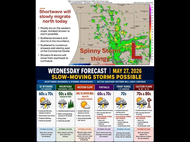
COLORADO AND SURROUNDING REGION — A slow-moving shortwave disturbance crawling from south to north Wednesday, May 27, 2026, is setting up a day of scattered to numerous showers and thunderstorms across Colorado and Wyoming, with the best coverage focused along and east of the Continental Divide.
The critical concern today is extremely slow storm motion with little steering current in place, meaning stronger cells will meander and potentially train over the same locations, producing heavy rain, frequent lightning, small hail, and localized gusty winds across the Front Range, foothills, and eastern plains.
Slow Storm Motion the Key Concern as Cells Capable of Training Over Same Locations
With virtually no steering current in place today, storms will move slowly from southeast to northwest and could repeatedly impact the same communities rather than quickly tracking through. This slow motion setup significantly increases the flash flooding potential wherever the most persistent cells develop through the afternoon and evening hours.
The Front Range and I-25 corridor will see scattered afternoon and evening storms with highs in the 70s, while the foothills see the best afternoon and evening coverage with slow-moving storms capable of heavy rain, frequent lightning, small hail, and localized gusty winds. Morning hours remain the safest window for outdoor activities and travel today.
Eastern Plains Carrying Best Rain Chances Wednesday Afternoon and Evening
The eastern plains including western Nebraska and western Kansas will see the best storm coverage Wednesday afternoon and evening with highs reaching the 70s and 80s. Slow-moving storms across this zone carry the same hazard profile of heavy rain, frequent lightning, small hail, and gusty winds as cells develop along and east of the Continental Divide through the day.
The mountains will see scattered showers and storms with better coverage along and east of the Divide, while the western slope stays mostly dry with only isolated afternoon storm chances and valley highs reaching the mid to upper 80s.
Active Pattern Continues Through the Weekend With Daily Storm Chances Persisting
The active weather pattern is expected to continue through the weekend and into next week with daily shower and thunderstorm chances remaining in the forecast. Thursday brings a possible brief lull before storm chances increase again Friday into the weekend across the region. Stay with NapervilleLocal.com for the latest weather updates and local forecast coverage.

I’ve lived in Naperville long enough to see how quickly our community changes — from new developments downtown to sudden shifts in our Midwest weather. Reporting on Naperville news and daily forecasts gives me the chance to keep neighbors informed about what really matters. My goal is simple: deliver clear, timely updates so you always know what’s happening in our city and what to expect from the skies above.