
Flash Flooding Potential Triggers Stage 2 Flood Alert for Houston and Southeast Texas as Tropical Moisture Could Bring 5 to 8+ Inches of Rain This Week
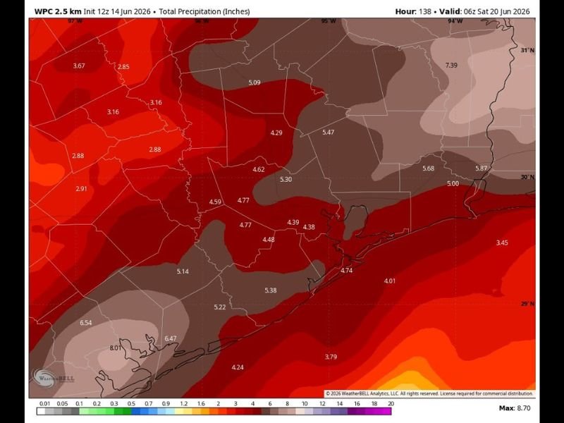
HOUSTON/SOUTHEAST TEXAS — A Stage 2 flood alert is now in effect for the Houston area and Southeast Texas as an influx of tropical moisture threatens to bring significant rainfall and potential flash flooding to the region through the week ahead. The latest WPC 7-day total precipitation forecast, valid through 6Z Saturday June 20, shows widespread totals of 4 to 8 inches or more across a large swath of Southeast Texas, with the exact placement and timing of the heaviest rain still uncertain.
Western and Southwestern Areas Could See Highest Totals Approaching 8 Inches
The highest rainfall totals on the forecast map are concentrated across the western and southwestern portions of the outlook area, where totals reach as high as 6.5 to 8 inches or more. This zone of darker shading represents the greatest flash flooding concern, where saturated ground combined with intense rainfall rates could lead to rapid water rises in low-lying areas and along creeks and bayous.
Forecasters emphasize that while the broad pattern supports heavy rain across the region, pinpointing exactly where the heaviest cores will set up remains difficult this far out.
Houston Metro and Surrounding Counties Forecast 4 to 5+ Inches
The Houston metro area and surrounding counties are forecast to see widespread totals in the 4 to 5.5 inch range over the seven-day period, with some pockets potentially exceeding that depending on how individual rounds of rain track through the week. Given how quickly Houston’s drainage systems can become overwhelmed, even these totals carry real flash flooding potential.
Areas along the upper Texas coast are seeing somewhat lower but still significant totals near 3.5 to 4.5 inches.
Stage 2 Flood Alert Means Heightened Awareness Is Needed Now
With a Stage 2 flood alert now active, residents across Houston and Southeast Texas should begin monitoring forecasts closely and avoid driving through flooded roadways under any circumstances. Low-lying areas, underpasses, and locations with a history of flooding should be avoided entirely once heavy rain begins.
This is an evolving situation, and updates on timing and the heaviest rainfall locations are expected as the week progresses. Stay with NapervilleLocal.com for the latest weather updates and local forecast coverage.

I’ve lived in Naperville long enough to see how quickly our community changes — from new developments downtown to sudden shifts in our Midwest weather. Reporting on Naperville news and daily forecasts gives me the chance to keep neighbors informed about what really matters. My goal is simple: deliver clear, timely updates so you always know what’s happening in our city and what to expect from the skies above.