
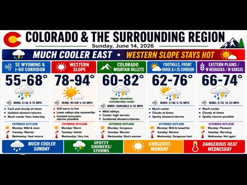
Much Cooler Air Settles East of the Divide Across Colorado With Spotty Storms Possible While Western Slope Stays Hot Near 94° Before Dangerous Heat Returns Wednesday
COLORADO — A significant temperature split is in place across Colorado and the surrounding region this Sunday, June 14, as a front that moved through Saturday has ushered in much cooler air east of the Continental Divide. Widespread 60s and 70s cover the Front Range, I-25 corridor, and eastern plains, while the Western Slope remains warm to hot with highs reaching the upper 80s and low 90s. A west-northwest flow with a shortwave disturbance will keep scattered clouds and the chance for spotty showers and thunderstorms in play through the day.
Front Range and Eastern Plains Enjoy Much Cooler Conditions Today
SE Wyoming and the I-80 Corridor are running 55 to 68°F today, the coolest readings in the region, with cool and cloudy conditions and isolated showers and storms possible. The Front Range and I-25 Corridor are sitting at 62 to 76°F with much cooler conditions, periodic clouds, and spotty showers and storms.
The Eastern Plains, western Nebraska, and western Kansas are forecast for 66 to 74°F with cloudy skies at times and spotty storms possible. Colorado Mountain Valleys are running 60 to 82°F, with considerably cooler conditions at higher elevations and scattered showers and storms.
Western Slope Holds Onto Heat With Highs Near 94°
The Western Slope remains the outlier today, with highs forecast in the 78 to 94°F range. Lower valleys stay summerlike and still warm to hot, while isolated mountain storms remain possible through the afternoon. West-southwest winds at 5 to 20 mph will keep conditions breezy at times.
Gorgeous Monday Gives Way to Dangerous Heat Wednesday
Monday is shaping up to be a standout day across the region, with mild and beautiful conditions, a mix of 70s to near 80, and only isolated showers near the Highway 50 corridor. Tuesday brings warming trends statewide as temperatures climb back toward the upper 80s and mid-90s depending on elevation.
Wednesday brings dangerous heat for one day, with widespread 90s and 100s expected. Forecasts call for 101°F in Grand Junction, 105°F in Pueblo, 104°F in La Junta, and 106°F in Lamar before a cooler front arrives Thursday. Stay with NapervilleLocal.com for the latest weather updates and local forecast coverage.

I’ve lived in Naperville long enough to see how quickly our community changes — from new developments downtown to sudden shifts in our Midwest weather. Reporting on Naperville news and daily forecasts gives me the chance to keep neighbors informed about what really matters. My goal is simple: deliver clear, timely updates so you always know what’s happening in our city and what to expect from the skies above.