
Damaging Wind Threat With Level 2 Severe Weather Targets New Jersey Through Virginia and the Mid-Atlantic as Cold Front Pushes Severe Storms East This Sunday
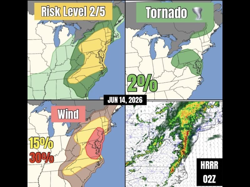
MID-ATLANTIC/NORTHEAST — A cold front continuing eastward today, June 14, is bringing showers and severe thunderstorms across the Mid-Atlantic and Northeast, with a Level 2 of 5 risk in place stretching from New Jersey through Virginia. This corridor is where the strongest wind shear and instability are located, setting up an environment where storms can rapidly transition into linear segments capable of producing widespread damaging winds.
New Jersey Through Virginia Corridor Faces Highest Wind Threat
The core damaging wind threat today is centered on a corridor running from New Jersey southward through Maryland, Washington D.C., and into Virginia. This zone carries a 30% wind probability, with a broader 15% wind probability extending across a larger swath covering Pennsylvania, Delaware, and parts of New York and New England.
Frontal forcing combined with favorable thermodynamic and kinematic profiles supports a quick transition from individual storms into organized linear segments, often called squall lines, which are efficient at producing widespread wind damage across a broad area in a short period of time.
Brief Weak Tornado Cannot Be Ruled Out Across Parts of the Northeast
While damaging winds are the headline threat today, a 2% tornado probability is in place across a zone extending from eastern Pennsylvania and New Jersey northward into New York, Connecticut, and southern New England. Forecasters note that a random brief and weak tornado cannot be entirely ruled out within this environment, particularly along any embedded rotating cells within the line.
The HRRR radar simulation valid for this evening shows an organized line of storms with embedded heavier cells stretching from the Mid-Atlantic northeastward into New England, consistent with the squall line evolution described in the outlook.
Storms Push East Through the Evening Hours
As the cold front continues its eastward progression today, the severe weather threat will track from the Mid-Atlantic into the Northeast through the afternoon and evening hours. Residents from New Jersey through Virginia should be especially alert given the elevated wind probabilities in this zone.
Secure loose outdoor items and have a plan ready for potential power outages as this line of storms moves through the region today. Stay with NapervilleLocal.com for the latest weather updates and local forecast coverage.

I’ve lived in Naperville long enough to see how quickly our community changes — from new developments downtown to sudden shifts in our Midwest weather. Reporting on Naperville news and daily forecasts gives me the chance to keep neighbors informed about what really matters. My goal is simple: deliver clear, timely updates so you always know what’s happening in our city and what to expect from the skies above.