
Rare Moderate Risk Level 4 Severe Weather Outbreak Hits the Stateline Including Rockford, Chicago With Tornadoes, 75+ MPH Winds, and Flash Flooding in Two Rounds Today
STATELINE REGION — The entire Stateline region has been upgraded to a Level 4 of 5 Moderate Risk for severe weather today, a designation issued only once every one to two years or more rarely. Two rounds of severe storms are expected, with the first arriving around midday carrying the greatest tornado threat, and the second striking between 3:00 PM and 7:00 PM bringing destructive winds, isolated tornadoes, heavy rain, and flash flooding.
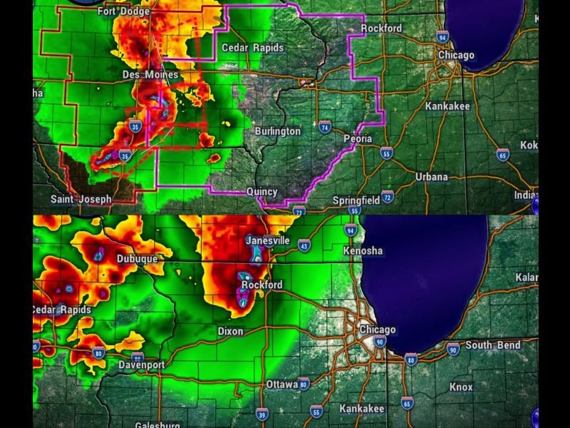
Round One Noon to 1 PM — Greatest Tornado Threat of the Day
The first round of storms is expected between roughly 11:00 AM and 1:00 PM and carries the highest tornado probability of the two waves. A Tornado Watch is already in effect for Stephenson, Jo Daviess, Carroll, and Whiteside Counties, with expansion of that watch eastward expected in the hours ahead.
Anyone across the Rockford corridor and surrounding areas should be in or near shelter before noon and treat any tornado warning issued with immediate urgency.
Round Two 3 PM to 7 PM — Destructive Winds and Flash Flooding
The second round, arriving between 3:00 PM and 7:00 PM, shifts the primary threat toward widespread damaging winds potentially reaching 75+ mph. This complex of storms may also produce isolated embedded tornadoes, making it dangerous on multiple fronts.
Heavy rain and flash flooding are additional concerns with this second wave, affecting areas including Rockford, Dixon, Chicago, Kenosha, Janesville, Davenport, and Ottawa. Multiple severe thunderstorm and tornado warnings are expected to be issued across the region during this window.
Warnings Will Be Issued — Have Your Plan Ready Now
Forecasters are explicitly stating that warnings will be issued today, likely on multiple occasions. Both tornado warnings and severe thunderstorm warnings must be taken seriously and acted upon immediately throughout the day.
Residents should finalize shelter plans before the first round arrives, keep weather alerts active on all devices, and avoid travel during the active storm windows. This is one of the most significant severe weather days for the Stateline region in recent years. Stay with NapervilleLocal.com for the latest weather updates and local forecast coverage.

I’ve lived in Naperville long enough to see how quickly our community changes — from new developments downtown to sudden shifts in our Midwest weather. Reporting on Naperville news and daily forecasts gives me the chance to keep neighbors informed about what really matters. My goal is simple: deliver clear, timely updates so you always know what’s happening in our city and what to expect from the skies above.