
Spotty Showers and Storms With Sporadic Wind Gusts Across Arkansas Including Little Rock, Fort Smith, and Jonesboro With Highs Settling in the 70s and Low 80s Thursday
ARKANSAS — A mix of mild temperatures, sporadic morning wind gusts, and the chance for spotty showers and storms will define Thursday’s weather picture across Arkansas, with high temperatures ranging from the mid-70s to the low 80s statewide. Better storm chances are expected to develop tonight after sunset, though the activity is not expected to be a statewide washout. Residents across the state should remain weather-aware through the day and into the evening as conditions evolve.
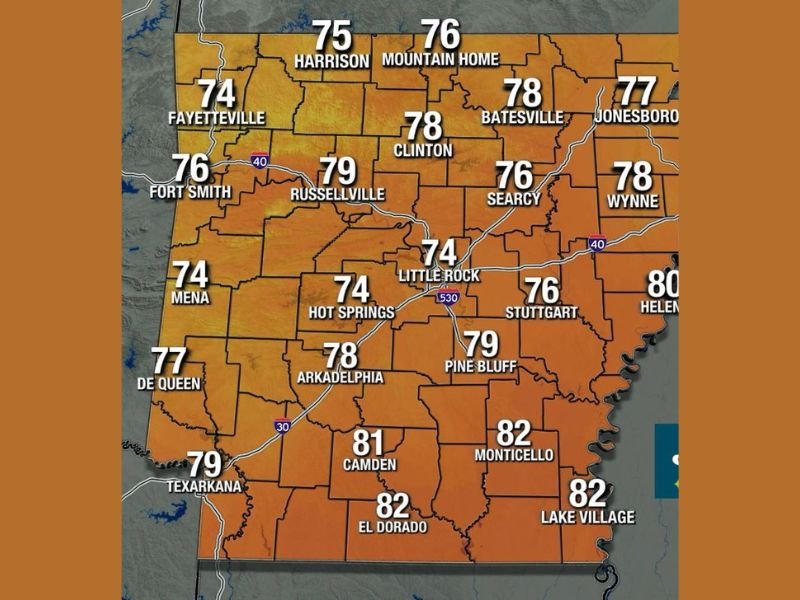
Statewide High Temperatures Settling Into the 70s With a Few 80s in the South
Temperatures across Arkansas on Thursday will be largely comfortable, with most of the state topping out in the 70s through the afternoon hours. Northern communities including Harrison and Mountain Home will see highs of 75 and 76 degrees respectively, while Fayetteville reaches 74 and Fort Smith climbs to 76.
Central Arkansas sits in a similar range, with Little Rock forecast at 74 degrees and Russellville reaching 79. The warmest readings will be concentrated across southern Arkansas, where El Dorado and Lake Village both reach 82 degrees, Monticello hits 82, Camden climbs to 81, and Helena tops out at 80.
Sporadic Morning Wind Gusts Expected to Settle Down Through the Afternoon Hours
Residents across Arkansas may notice some blustery and sporadic wind gusts during the morning hours on Thursday. Forecasters indicate this activity should calm down as the afternoon progresses, making conditions more settled heading into the midday and early afternoon period.
The morning gusts are not expected to cause significant impacts, but they may be noticeable enough to affect outdoor activities or travel during the earlier parts of the day. Conditions should improve considerably once the afternoon hours arrive across the state.
Spotty Shower and Storm Chances Cannot Be Ruled Out Through the Day Thursday
While Thursday will not be a complete washout, spotty showers and storms cannot be fully ruled out at any point through the day across Arkansas. The activity through the daytime hours is expected to remain isolated and scattered in nature rather than widespread or organized.
Storm chances increase more meaningfully tonight after sunset, when better atmospheric conditions support a higher likelihood of shower and storm development across portions of the state. Residents with evening outdoor plans should monitor conditions and be prepared to seek shelter if storms develop after dark.
Evening Storm Chances Increase After Sunset Across Portions of Arkansas Thursday Night
The post-sunset hours carry the best storm chances of the entire Thursday forecast period for Arkansas. While the event is not expected to be a statewide severe weather situation, localized heavy rain and lightning will be possible across portions of the state through the overnight period.
Staying connected to local weather alerts and having a plan for evening storm activity is recommended for residents statewide. The combination of daytime spotty activity and an elevated overnight storm chance makes Thursday a day that warrants consistent weather awareness from morning through night. Stay with NapervilleLocal.com for the latest weather updates and local forecast coverage.

I’ve lived in Naperville long enough to see how quickly our community changes — from new developments downtown to sudden shifts in our Midwest weather. Reporting on Naperville news and daily forecasts gives me the chance to keep neighbors informed about what really matters. My goal is simple: deliver clear, timely updates so you always know what’s happening in our city and what to expect from the skies above.