
Southwestern Lower Michigan Including Grand Rapids and Muskegon Face Severe Thunderstorm Threat Through 3 AM as Mesoscale Convective Vortex Crosses Lake Michigan
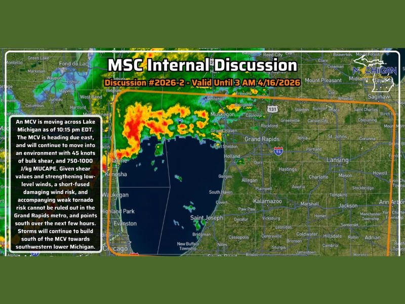
SOUTHWESTERN LOWER MICHIGAN — An internal severe weather discussion has been issued for much of southwestern lower Michigan, valid through 3 AM EDT on April 16, 2026, as a mesoscale convective vortex is actively moving east across Lake Michigan toward the lakeshore.
The system is tracking toward Muskegon and Grand Haven, with current trajectory placing the vortex into the lakeshore area by 11 PM EDT. Severe thunderstorms will remain possible through 3 AM, primarily across west Michigan, though not everyone in the watch area will see severe weather.
Mesoscale Convective Vortex Tracking Toward the Lakeshore
A mesoscale convective vortex, commonly referred to as an MCV, is an area of localized low pressure that can significantly enhance storm development and intensity in a very concentrated zone. As of 10:15 PM EDT, this MCV is moving due east across Lake Michigan and is expected to arrive along the lakeshore by 11 PM.
When an MCV moves onshore, it can rapidly strengthen existing storms and produce a swath of damaging winds across a highly localized area. With sufficient spin present within the vortex, a low tornado threat also cannot be completely ruled out as the system makes landfall.
Grand Rapids Metro and Points South Face the Greatest Risk
The technical discussion highlights the Grand Rapids metro and areas southward as the primary zone of concern over the next few hours. The MCV is moving into an environment featuring 45 knots of bulk shear and MUCAPE values of 750 to 1,000 J/kg, providing enough energy and wind shear to support organized and dangerous storm development.
Given those atmospheric values and strengthening low-level winds, a short-fused damaging wind event and an accompanying weak tornado risk cannot be ruled out across the Grand Rapids metro and communities to the south. Storms are also expected to continue building south of the MCV toward the broader southwestern lower Michigan area.
Damaging Winds Are the Primary Threat
Among the hazards associated with tonight’s MCV passage, damaging winds stand out as the most significant and widespread concern. The combination of the vortex’s own circulation and the bulk wind shear in the environment creates conditions favorable for brief but intense wind events that can cause localized damage with very little warning time.
Residents across Muskegon, Grand Haven, Grand Rapids, and surrounding communities should be aware that conditions can deteriorate rapidly as the MCV moves onshore and interacts with existing storm activity south of its track.
Tornado Threat Remains Low but Cannot Be Ruled Out
While the primary concern tonight is damaging winds, forecasters are not dismissing the tornado possibility entirely. With enough rotational energy within the MCV and strengthening low-level winds in place, a brief and weak tornado spin-up remains a non-zero threat across the affected zone through the overnight hours.
Residents should have a shelter plan ready and multiple ways to receive weather alerts active through 3 AM, even if the overall tornado probability remains on the lower end of the severe weather spectrum.
Threat Continues Through 3 AM for West Michigan
The severe weather window remains open across southwestern lower Michigan through 3 AM EDT. Storms will continue to develop and build south of the MCV track during this period, meaning the threat will not end quickly once the initial lakeshore impacts are felt.
Anyone across the highlighted discussion zone should remain weather-aware through the overnight hours, avoid unnecessary travel, and be prepared to seek shelter immediately if warnings are issued for their specific location. Stay with NapervilleLocal.com for the latest weather updates and local forecast coverage.

I’ve lived in Naperville long enough to see how quickly our community changes — from new developments downtown to sudden shifts in our Midwest weather. Reporting on Naperville news and daily forecasts gives me the chance to keep neighbors informed about what really matters. My goal is simple: deliver clear, timely updates so you always know what’s happening in our city and what to expect from the skies above.