
Isolated Tornado and Very Large Hail Threat Targeting Western Dakotas Including Rapid City Bismarck and Pierre With Supercells Firing Tuesday Afternoon
WESTERN DAKOTAS — A tornado and very large hail threat is developing across the western Dakotas Tuesday afternoon as supercells are expected to fire across eastern Wyoming and Colorado by 4 PM before sliding northward around the Black Hills into the primary threat zone.
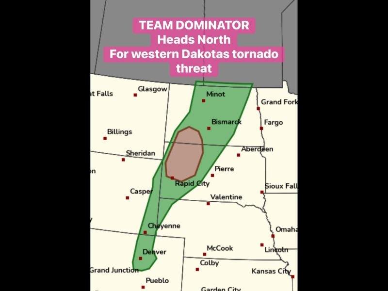
The outlook map places a concentrated brown hatched zone centered between Rapid City and Bismarck indicating the highest potential for very large hail, sitting inside a broader green marginal risk corridor stretching from Denver northward through Pierre and Minot. Storms accelerating around the north side of the Black Hills through the easterly flow will be the key mechanism driving the isolated tornado potential.
Supercells Fire Eastern Wyoming and Colorado by 4 PM Before Sliding North
Initial supercell development is expected across eastern Wyoming and Colorado by 4 PM Tuesday, with storms then tracking northeastward and accelerating through the easterly flow wrapping around the north side of the Black Hills. This storm mode and track is particularly favored for producing both very large hail and isolated tornadoes as cells tap into the unstable air mass across the western Dakotas. The Deadwood and Rapid City corridor sits directly in the path of this anticipated storm track.
Brown Hatched Zone Between Rapid City and Bismarck Marks Highest Hail Threat
The brown hatched zone on the outlook map covering the area between Rapid City and Bismarck represents the highest concentration of very large hail potential with this supercell setup. Hail of significant size is capable of causing severe damage to vehicles, crops, rooftops, and any exposed property across this corridor. Residents across western South Dakota and south-central North Dakota should secure vehicles and property ahead of the afternoon storm window.
Isolated Tornado Possible as Storms Accelerate Through Black Hills Easterly Flow
Any storms that slide through the accelerated easterly flow around the north side of the Black Hills carry an isolated tornado threat in addition to the hail hazard. The green risk zone extends broadly from Denver through Cheyenne, Rapid City, Pierre, and northward through Bismarck and Minot, covering a long corridor of potential storm impacts. Residents across the entire green zone should remain weather-aware through the evening hours Tuesday.
Stay with NapervilleLocal.com for the latest weather updates and local forecast coverage.

I’ve lived in Naperville long enough to see how quickly our community changes — from new developments downtown to sudden shifts in our Midwest weather. Reporting on Naperville news and daily forecasts gives me the chance to keep neighbors informed about what really matters. My goal is simple: deliver clear, timely updates so you always know what’s happening in our city and what to expect from the skies above.