
Severe Weather Risk Increases Across Indiana From Gary and South Bend to Indianapolis and Bloomington, With Hail Threat Wednesday and Stronger Storms Possible Friday
INDIANA — A warmer and more active weather pattern is taking shape across the state, bringing increasing thunderstorm chances and a growing concern for both severe weather and heavy rain as the week unfolds.
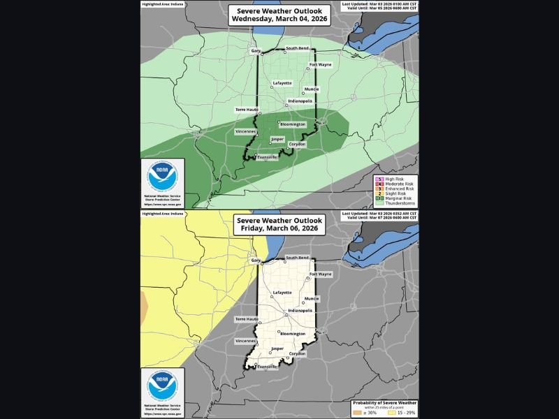
Forecast outlook maps show a marginal risk (Level 1 of 5) for severe storms Wednesday, followed by a more substantial Level 2 of 5 risk positioned just west of Indiana on Friday — a setup that could shift east into parts of the state late Friday into early Saturday.
Wednesday: Marginal Risk Focused on Southern Indiana
The Wednesday, March 4 severe weather outlook highlights much of Indiana in a broad marginal risk area, with the greatest concern across southern Indiana, including areas near:
- Bloomington
- Vincennes
- Jasper
- South of Indianapolis
Cities such as Indianapolis, Lafayette, Terre Haute, Muncie, Fort Wayne, Gary and South Bend sit within the broader green-shaded zone, indicating isolated severe potential but not widespread high-end risk.
The primary concern Wednesday appears to be large hail, particularly in southern counties where instability may be slightly higher.
While the risk level remains on the lower end, forecasters note that even marginal setups can produce isolated stronger cells capable of brief damaging wind gusts or hail.
Friday: Higher Risk Just West, Watching Closely
By Friday, March 6, the severe weather outlook shifts and intensifies just west of Indiana, with a Level 2 (slight risk) area positioned over portions of Illinois and surrounding states.
Western Indiana — including areas near Gary, Lafayette and Terre Haute — sits closer to this higher-risk zone. Central locations such as Indianapolis and Bloomington remain in a lower probability area for now, but that could change depending on how the system evolves.
Forecasters are watching closely to see if severe weather pushes farther east into Indiana late Friday into Saturday morning.
If storms strengthen and track east, threats could include:
- Damaging wind gusts
- Large hail
- Heavy rainfall leading to localized flooding
Heavy Rain Also a Concern
In addition to severe storms, this active pattern raises concern for multiple rounds of rain, increasing the potential for ponding and localized flooding, especially in areas that receive repeated downpours.
As temperatures warm, atmospheric moisture will increase — fueling both thunderstorm development and heavier rainfall rates.
Early March Pattern Turning Active
This shift toward a warmer, stormier setup marks a noticeable change from quieter early-week conditions. While widespread severe weather is not guaranteed, the pattern is trending more dynamic.
Residents across Gary, South Bend, Fort Wayne, Indianapolis, Lafayette, Terre Haute and Bloomington should ensure they have:
- Multiple ways to receive weather warnings
- A plan in place in case storms intensify
- Awareness of potential overnight timing late Friday
Forecasters are also monitoring another possible system early next week, suggesting this active stretch may not be short-lived.
For continued updates as conditions evolve and confidence increases, stay connected with NapervilleLocal.com for the latest regional severe weather coverage.

I’ve lived in Naperville long enough to see how quickly our community changes — from new developments downtown to sudden shifts in our Midwest weather. Reporting on Naperville news and daily forecasts gives me the chance to keep neighbors informed about what really matters. My goal is simple: deliver clear, timely updates so you always know what’s happening in our city and what to expect from the skies above.