
Colorado Storm Brings Rain to Denver, Snow to Laramie and Cheyenne Ridge, With Wet Snow Possible Near Colorado Springs and Pueblo This Afternoon
COLORADO — A complex early-March storm system is sweeping across the Front Range and central Rockies today, bringing a mix of valley rain, mountain snow, isolated thunderstorms, and even the potential for wet snow down to around 6,000 feet in parts of southern Colorado.
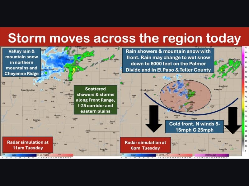
The system is already producing lower-elevation rain and heavier mountain snow this morning, particularly across the northwest plateau, northern Colorado mountains, southern Wyoming and the Cheyenne Ridge.
Morning: Rain Along I-25, Snow in Higher Terrain
As of late morning, radar simulations show:
- Rain showers along the Front Range, including areas near Fort Collins, Denver and Boulder
- Mountain snow across the northern mountains, with impacts possible near Steamboat Springs and higher elevations west of Fort Collins
- Mixed precipitation near Laramie and Cheyenne, where rain may change to wet snow at times
Farther east, showers and a few isolated thunderstorms are expected to stretch across the northern Front Range into the Nebraska Panhandle.
Afternoon: Cold Front Pushes South
By early to mid-afternoon, the center of low pressure moves into north-central Colorado, dragging a cold front southward.
Ahead of the front, temperatures are expected to rise into the 60s and even low 70s across parts of the eastern plains. Behind it, cooler air settles in with highs dropping into the 40s and 50s.
As the front slides across the Palmer Divide and into southern Colorado later this afternoon and evening, showers are forecast to expand southward, potentially reaching:
- El Paso County
- Pueblo County
- Portions of Teller County
North winds are expected to increase behind the front, generally 5–15 mph with gusts up to 25 mph.
Wet Snow Possible Near 6,000 Feet
One of the more notable aspects of today’s system is the potential for rain to briefly change to wet snow down to around 6,000 feet, especially across:
- The Palmer Divide
- Cheyenne Ridge in southeast Wyoming
- Higher terrain in El Paso and Teller counties
If this scenario verifies, slushy or slick conditions could develop for a time before precipitation tapers off later tonight into early Wednesday morning.
Mountain Travel Impacts
Embedded snow squalls are possible in the central mountains, which could create difficult travel conditions over:
- Monarch Pass
- The Eisenhower Tunnel
- Berthoud Pass
Drivers traveling north of Highway 50 or through higher elevations should be prepared for sudden reductions in visibility and snow-covered roadways.
More Systems Ahead
This storm is just part of a broader active pattern. Another system and associated cold front are expected late Thursday into Friday, bringing additional mountain snow and the potential for rain and snow at lower elevations.
While the weekend may start drier, the pattern looks unsettled again heading into next week.
For continued coverage of significant regional weather events and national storm trends, stay updated with NapervilleLocal.com.

I’ve lived in Naperville long enough to see how quickly our community changes — from new developments downtown to sudden shifts in our Midwest weather. Reporting on Naperville news and daily forecasts gives me the chance to keep neighbors informed about what really matters. My goal is simple: deliver clear, timely updates so you always know what’s happening in our city and what to expect from the skies above.