
North Texas and Western Arkansas Under Evening Severe Storm Threat With Large Hail Risk Highest Near DFW
North Texas and Western Arkansas — A developing round of strong to severe thunderstorms is expected later today, with the greatest coverage stretching from North Texas, including the DFW area, into western Arkansas. Forecasters indicate that large hail will be the primary hazard, especially as storms cluster ahead of a sagging frontal boundary during the evening hours.
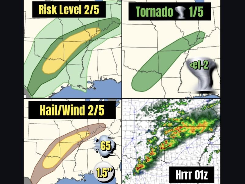
Risk Level and Areas of Concern
Today’s overall severe setup is rated at Risk Level 2 out of 5, meaning scattered strong storms are possible but not widespread extreme activity. The most active zone is projected from north Texas into western Arkansas, where storm clusters are expected to form and strengthen later in the day.
This corridor includes the Dallas–Fort Worth Metroplex, where higher storm coverage may increase the likelihood of localized severe impacts.
Large Hail Leads the Threat List
The main concern today is large hail, with hail and wind hazards also rated at 2 out of 5. Forecast guidance suggests hail up to 1.5 inches in diameter could occur in the strongest storms. Hail of that size can dent vehicles, damage roofs and siding, and pose dangers to drivers caught in heavy cores.
Storm organization into clusters can enhance updraft strength, which increases hail production. Residents are encouraged to move vehicles under cover before storms arrive, especially during the late afternoon and evening.
Damaging Wind Potential
In addition to hail, storms could produce wind gusts near 65 mph. These gusts are strong enough to down small tree limbs, scatter unsecured outdoor objects, and cause isolated power outages.
If storms merge into more organized lines, wind damage could become more widespread within the affected corridor from north Texas through western Arkansas.
Tornado Risk Remains Low
The tornado threat is rated at 1 out of 5, and any tornado that develops would likely be brief and weak. While the overall tornado risk is low, isolated spin-ups cannot be ruled out, particularly where storms interact with boundary features.
Residents should remain alert to warnings even if the tornado threat is not the primary concern today.
Evening Timing and Preparedness
Storm intensity is expected to increase later in the evening as the frontal boundary provides added lift. This timing could bring stronger storms during peak travel hours or after sunset, when visibility decreases.
Those in North Texas, DFW, and western Arkansas should monitor weather alerts, secure loose outdoor items, and prepare for sudden heavy rainfall, hail, and strong wind bursts.
For continued weather updates and regional coverage, follow NapervilleLocal.com and stay prepared as storms develop across the southern Plains and lower Mississippi Valley tonight.

I’ve lived in Naperville long enough to see how quickly our community changes — from new developments downtown to sudden shifts in our Midwest weather. Reporting on Naperville news and daily forecasts gives me the chance to keep neighbors informed about what really matters. My goal is simple: deliver clear, timely updates so you always know what’s happening in our city and what to expect from the skies above.