
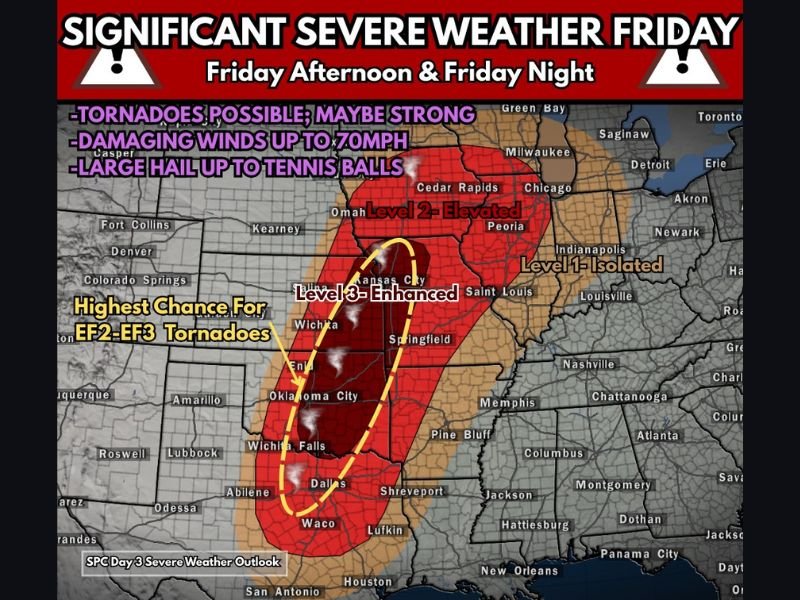
Texas to Minnesota Braces for Level 3 Severe Weather Friday as Oklahoma, Kansas, and Missouri Face Strong Tornado Threat
TEXAS — A significant severe weather outbreak is increasingly likely Friday as the Storm Prediction Center maintains a Level 3 (Enhanced Risk) across parts of the central United States, highlighting the potential for damaging winds, large hail, and strong tornadoes.
The severe threat zone stretches from Texas northward into Minnesota, with the most intense storms expected across Oklahoma, Kansas, and Missouri, where atmospheric conditions appear most supportive of strong supercells.
Level 3 Enhanced Risk Centered on Oklahoma, Kansas, and Missouri
Forecast data shows the highest tornado potential from north Texas through Oklahoma into Kansas and western Missouri. This area sits within the Enhanced (Level 3) risk zone, meaning numerous severe storms are possible, including some that could become significant.
Meteorologists indicate the low-level jet will strengthen across this corridor, increasing wind shear and supporting rotating supercells capable of producing EF2 to EF3 strength tornadoes.
Cities including Dallas, Wichita Falls, Oklahoma City, Wichita, Kansas City, Springfield, and St. Louis fall within or near the higher-end risk zone.
Strong Tornado Potential (EF2–EF3)
Forecasters are specifically calling attention to the possibility of strong tornadoes, not just brief spin-ups. The corridor from north Texas through central Oklahoma into eastern Kansas and western Missouri is highlighted as having the highest chance for EF2–EF3 tornadoes.
These stronger tornadoes can cause significant structural damage, uproot trees, and produce long-track paths if storms remain isolated and discrete.
While tornado coverage will depend on storm evolution, the atmospheric setup suggests conditions could support powerful supercells before storms merge into larger clusters.
Damaging Winds and Large Hail Also Likely
In addition to tornadoes, storms could produce damaging wind gusts up to 70 mph. Winds of that magnitude can down power lines, snap tree limbs, and create hazardous driving conditions.
Large hail is also a major concern, with some storms capable of producing hail as large as tennis balls. Hail of that size can severely damage vehicles, roofing, and windows.
Timing: Friday Afternoon Into the Overnight Hours
The most active severe weather window is expected Friday afternoon through Friday night, potentially continuing into the overnight hours as storms track northeast.
The severe threat expands northward into parts of Iowa, Illinois, and Minnesota, though the highest intensity remains centered farther southwest.
Residents across the Enhanced risk area should review severe weather plans, ensure weather alerts are enabled, and identify safe shelter locations in case warnings are issued.
Stay with NapervilleLocal.com for continuing updates as the Friday severe weather setup becomes clearer and forecasters refine storm timing and impact zones.

I’ve lived in Naperville long enough to see how quickly our community changes — from new developments downtown to sudden shifts in our Midwest weather. Reporting on Naperville news and daily forecasts gives me the chance to keep neighbors informed about what really matters. My goal is simple: deliver clear, timely updates so you always know what’s happening in our city and what to expect from the skies above.