
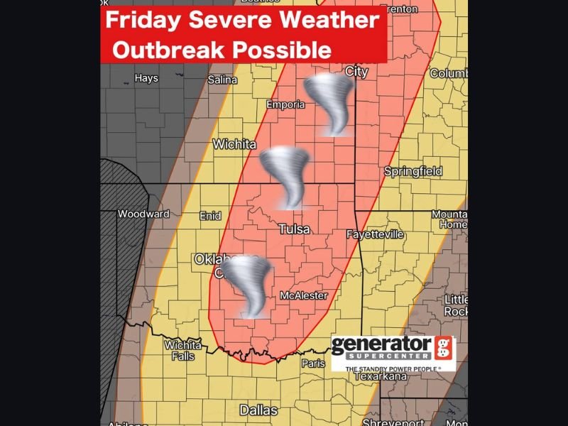
Oklahoma Braces for Potential Friday Severe Weather Outbreak as Central and Eastern Areas Face Rising Tornado, Hail, and Wind Threat
OKLAHOMA — Confidence is increasing that a round of strong to severe storms could develop across much of the state Friday afternoon and evening, with the highest risk centered over central and eastern Oklahoma, including areas near Oklahoma City, Tulsa, and McAlester.
Forecasters indicate that a strengthening storm system moving into the Plains will create an environment supportive of severe weather development later in the day.
Storm Development Likely After 4 PM Friday
Current projections suggest storms will begin forming after 4 p.m. Friday, initially across western portions of the state before spreading eastward into more populated areas.
The setup features increasing atmospheric instability, strengthening wind shear, and a dryline pushing east, a combination that can allow storms to intensify quickly during the late afternoon and evening hours.
Central and Eastern Oklahoma Under Highest Risk
The most concerning zone currently appears to stretch from Oklahoma City northeast toward Tulsa and into parts of eastern Oklahoma. This corridor is highlighted as having the strongest potential for severe storms if conditions align.
Cities including Tulsa, McAlester, and Oklahoma City are within the core area where storms may remain more organized and potentially isolated before merging into clusters.
Main Threats: Large Hail and Damaging Winds
Large hail and damaging straight-line winds are expected to be the primary hazards. Strong updrafts could support hail capable of causing property damage, while wind gusts may be strong enough to down tree limbs and cause scattered power outages. As storms grow and intensify during the evening, the wind threat may become more widespread.
Tornado Risk Cannot Be Ruled Out
While hail and wind are the primary concerns, a few tornadoes cannot be ruled out, particularly if storms remain more isolated. Isolated supercells within a favorable shear environment could produce brief tornadoes before transitioning into larger storm clusters.
The exact placement of the highest tornado potential may shift as new data becomes available, but current trends point toward central and eastern sections of the state.
Timing and Ongoing Updates
The severe threat window extends from late Friday afternoon into the evening hours. Forecasters note that it is still several days out, meaning details may adjust as new model guidance refines storm placement and intensity.
Residents across Oklahoma are encouraged to monitor forecasts closely, review severe weather safety plans, and ensure alerts are enabled ahead of Friday. Stay with NapervilleLocal.com for continued updates as this potential severe weather setup develops across the southern Plains.

I’ve lived in Naperville long enough to see how quickly our community changes — from new developments downtown to sudden shifts in our Midwest weather. Reporting on Naperville news and daily forecasts gives me the chance to keep neighbors informed about what really matters. My goal is simple: deliver clear, timely updates so you always know what’s happening in our city and what to expect from the skies above.