
Western Lower Michigan Placed Under Marginal Severe Weather Risk Friday Night as Storm Chances Increase After Dark
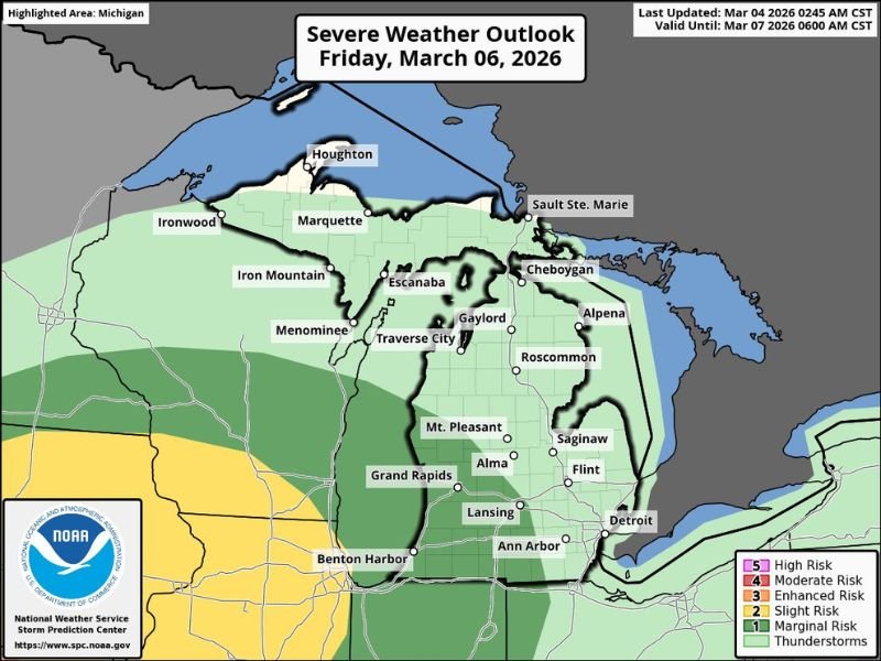
MICHIGAN — The Storm Prediction Center has placed portions of western lower Michigan under a Level 1 out of 5 marginal risk for severe weather Friday, signaling that isolated strong storms could develop later in the day.
While this is the lowest category on the severe weather scale, it does indicate that a few storms may briefly reach severe limits, especially as instability increases during the evening hours.
Marginal Risk Focused on Western Lower Michigan
The highlighted risk area includes communities such as Grand Rapids, Benton Harbor, Lansing, Mt. Pleasant, Alma, Saginaw, and Flint, along with surrounding counties in western and central lower Michigan.
Farther north, areas including Traverse City, Gaylord, Alpena, and Cheboygan are under general thunderstorm outlook zones, meaning storms are possible but the severe risk is lower. The Marginal Risk category suggests isolated severe storms could occur, but widespread severe weather is not expected at this time.
Timing: Late Evening Into Early Saturday
If severe weather develops, it would most likely occur later Friday evening into early Saturday morning, particularly after sunset. Forecast data shows the bulk of atmospheric instability arriving during the evening hours, increasing the potential for storms to strengthen after dark. Overnight severe setups can sometimes catch residents off guard, making weather alerts especially important.
Potential Hazards Remain Uncertain
At this stage, specific hazards have not been fully defined. However, in marginal setups, the most common risks typically include:
- Isolated damaging wind gusts
- Small hail
- Brief heavy downpours
The overall setup does not currently indicate a widespread or high-end severe outbreak, but isolated stronger storms cannot be ruled out.
Monitoring Updates as Details Refine
Forecasters emphasize that this event is still evolving, and exact storm placement, timing, and intensity may shift as newer data becomes available.
Residents across western lower Michigan, particularly near Grand Rapids and Benton Harbor, should monitor forecasts heading into Friday night and ensure weather notifications are enabled in case warnings are issued after dark. Stay with NapervilleLocal.com for continued updates as Friday’s system approaches and forecasters refine the severe weather outlook for Michigan.

I’ve lived in Naperville long enough to see how quickly our community changes — from new developments downtown to sudden shifts in our Midwest weather. Reporting on Naperville news and daily forecasts gives me the chance to keep neighbors informed about what really matters. My goal is simple: deliver clear, timely updates so you always know what’s happening in our city and what to expect from the skies above.