
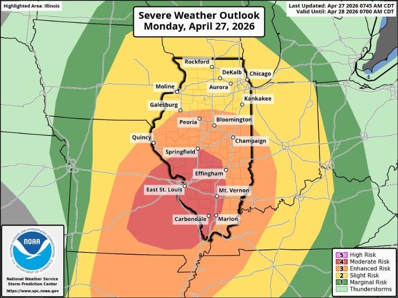
Tornadoes, Large Hail, and Damaging Winds Targeting Illinois Including East St. Louis, Carbondale, and Springfield With Moderate Risk Introduced for Southwest Illinois Today
ILLINOIS — The Storm Prediction Center has introduced a Level 4 Moderate Risk for southwest Illinois as of Monday morning, April 27, 2026, covering communities including East St. Louis, Carbondale, Marion, Springfield, and Effingham. The tornado and large hail threat is highest within this Moderate Risk corridor, while damaging winds remain a significant concern across much of the rest of the state. Two rounds of storm activity are expected today, with morning and early afternoon storms carrying a wind and hail threat followed by additional storms pushing through along the cold front this evening.
Moderate Risk Core Covers Southwest Illinois With Highest Tornado and Hail Threat
The newly introduced Moderate Risk zone across southwest Illinois represents the highest risk designation in the state today, where the combination of tornado potential and large hail threat is greatest. Communities including East St. Louis, Carbondale, Marion, Mt. Vernon, and Springfield sit within or near this elevated risk corridor and face the most significant severe weather outcomes of any area in Illinois today.
An Enhanced Risk zone surrounds the Moderate core and extends across a broader swath of central and southern Illinois, including Quincy, Champaign, and Effingham. Residents across the Moderate and Enhanced zones should treat today as a high-impact severe weather day and have shelter plans finalized before storms arrive.
Peoria and Bloomington Face Morning Wind and Hail Threat Before Evening Cold Front Storms
For the Peoria and Bloomington market, forecasters note the area sits far enough north to avoid the brunt of the stronger supercells expected later today. However, storms moving through late this morning and into the early afternoon will still carry a damaging wind and hail threat that residents in those communities should not dismiss.
A second round of storms is then expected along the cold front during the evening hours, extending the severe weather window across much of Illinois well into the night. The two-round nature of today’s setup means residents across the state should remain weather aware from morning through late evening.
Damaging Winds Remain a Statewide Threat Across Much of Illinois Today
While the tornado and large hail threat is most concentrated across southwest Illinois, damaging winds pose a risk across a much broader footprint covering the majority of the state. Straight-line wind damage can occur well ahead of and alongside storm cores, affecting communities outside of direct tornado warning areas.
Northern Illinois communities including Rockford, DeKalb, Aurora, and Chicago fall within the Slight Risk zone and face a primarily wind-driven severe weather threat today. Residents statewide should keep weather alerts active and be prepared to take shelter quickly as storm systems evolve through the day and into the evening. Stay with NapervilleLocal.com for the latest weather updates and local forecast coverage.

I’ve lived in Naperville long enough to see how quickly our community changes — from new developments downtown to sudden shifts in our Midwest weather. Reporting on Naperville news and daily forecasts gives me the chance to keep neighbors informed about what really matters. My goal is simple: deliver clear, timely updates so you always know what’s happening in our city and what to expect from the skies above.