
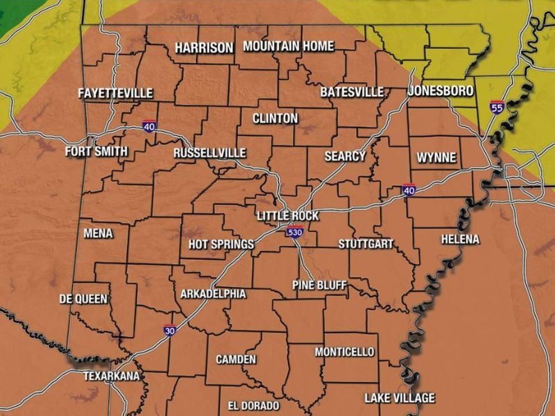
Strong Winds and Hail Threat Across Arkansas Including Little Rock, Fort Smith, and Fayetteville With Medium Risk Level 3 of 5 in Place Through Tuesday Afternoon
ARKANSAS — Severe weather is possible today across a large majority of Arkansas, Tuesday, April 28, 2026, with storm coverage expected to be higher than the previous two days through mid-day and into the early evening hours. Most of the state is sitting under a Medium Risk Level 3 of 5, with the greatest concern focused across western, southern, and central Arkansas through the afternoon. Clusters of storms capable of producing strong winds and hail are the primary threats today, while the tornado risk remains low but not zero across the affected area.
Medium Risk Level 3 Covers Most of Arkansas With Western and Central Regions at Greatest Risk
The Medium Risk designation covers the vast majority of Arkansas today, reflecting a meaningful and widespread severe weather threat across the state. The greatest concentration of storm activity and severe potential is expected across western, southern, and central Arkansas, where communities including Fort Smith, Mena, Russellville, Little Rock, Hot Springs, Arkadelphia, and Texarkana all fall within the highest risk corridor.
Unlike the previous two days where storm coverage was more limited and isolated, today’s setup favors higher storm coverage through the mid-day and early evening hours. This broader coverage means more communities across Arkansas will encounter severe weather conditions at some point during the afternoon.
Strong Winds and Hail Are Primary Hazards With Clusters of Storms Today
Clusters of storms are the expected storm mode today, a configuration that strongly favors widespread damaging wind gusts and hail production across the affected area. This type of storm organization can deliver hazardous conditions across a broad geographic footprint simultaneously, making it important for all residents across the Medium Risk zone to remain weather aware through the afternoon hours.
Hail and strong wind gusts capable of causing property damage and downed trees are the headline hazards with today’s storm clusters. Residents across the western and central corridors should secure outdoor items and keep vehicles protected before storms develop through the mid-day hours.
Tornado Risk Low but Not Zero Across the State Through the Afternoon
While the tornado risk today is considered low overall, forecasters note it is not zero and isolated brief tornadoes cannot be completely ruled out with today’s storm clusters. The primary severe weather concern remains wind and hail, but any storm producing a tornado could do so with limited warning time given the cluster storm mode expected today.
Conditions are expected to clear out completely by the evening hours tonight, with no overnight severe weather threat anticipated. Residents can expect a return to quieter conditions after early evening as the storm system exits the region. Stay with NapervilleLocal.com for the latest weather updates and local forecast coverage.

Naperville is a community with stories that deserve to be told — both the serious ones about safety and justice, and the lighter ones that capture our culture and daily life. I focus on covering crime reports and court updates while also highlighting the traditions, events, and social trends that shape who we are. Through my reporting, I want to give readers a fuller picture of Naperville — the challenges we face and the character that keeps our city strong.