
Ominous Storm System Rolling Into Western Arkansas Including Mulberry and Surrounding Communities With Rain and Storms Favored Tuesday Morning
WESTERN ARKANSAS — A striking and ominous storm system is pushing into western Arkansas Tuesday morning, with dramatic shelf cloud structure already visible over the Mulberry area as the leading edge of the complex moves through. Western Arkansas is the favored zone for rain and storm activity across the state today, with forecasters monitoring radar closely as the system develops. Temperatures will run a touch cooler across Arkansas as a result of the storm activity moving through the region.
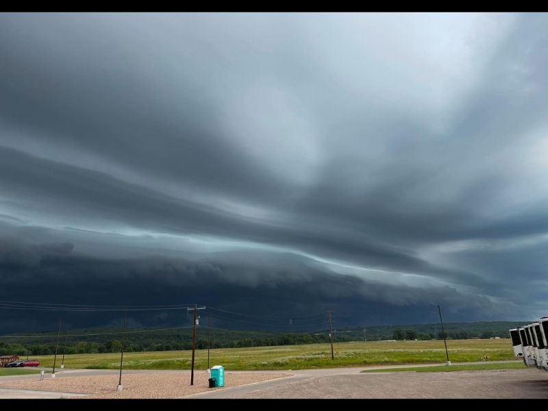
Dramatic Shelf Cloud Structure Captured Over Mulberry as Storms Push In
A striking shelf cloud photographed over Mulberry captures the intensity and organization of the storm system now moving into western Arkansas Tuesday morning. Shelf clouds of this structure indicate a strong and well-organized storm complex with a defined gust front pushing outward ahead of the heaviest rainfall. Residents in Mulberry and surrounding communities in the Arkansas River Valley corridor should expect rapidly changing conditions as this system moves through.
Western Arkansas the Favored Zone for Rain and Storm Coverage Today
Forecasters are identifying western Arkansas as the area most favored for rain and storm activity across the state throughout Tuesday. The atmospheric setup is supporting storm development and sustaining coverage across this portion of the state more than central or eastern Arkansas at this time. Anyone with outdoor plans across the western counties should expect periods of heavy rain, gusty winds, and reduced visibility as storms track through the region.
Cooler Temperatures Across Arkansas Offer Some Relief Behind Storm Passage
One positive aspect of Tuesday’s storm system is the cooler air mass trailing the activity, which will bring slightly lower temperatures across the entire state compared to recent days. The combination of cloud cover, rainfall, and post-frontal cooling will make conditions noticeably more comfortable once the storms clear through. Forecasters are continuing to watch radar developments closely and residents across western Arkansas should stay weather-aware throughout the morning and into the early afternoon hours. Stay with NapervilleLocal.com for the latest weather updates and local forecast coverage.

I’ve lived in Naperville long enough to see how quickly our community changes — from new developments downtown to sudden shifts in our Midwest weather. Reporting on Naperville news and daily forecasts gives me the chance to keep neighbors informed about what really matters. My goal is simple: deliver clear, timely updates so you always know what’s happening in our city and what to expect from the skies above.