
Rockford, Milwaukee, and Chicago Area Storm Line Weakening Wednesday Night but Strong Wind Gusts Still Expected Ahead of Arriving System
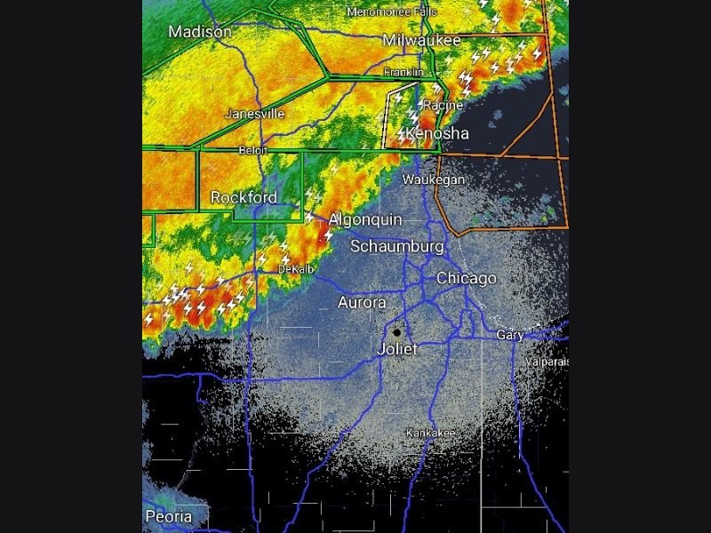
NORTHERN ILLINOIS AND SOUTHERN WISCONSIN — A 9:33 PM Wednesday night update confirms that the approaching storm line is weakening drastically as it pushes eastward across the region. Radar shows the line currently impacting areas from Rockford through Madison and tracking toward Milwaukee, Racine, and Kenosha. While the storms themselves are no longer considered severe, a burst of very strong winds racing out ahead of the line remains a concern for communities still awaiting its arrival.
Storms Choking Off Their Own Warm Air Supply
The rapid weakening of the storm line is being driven by a self-defeating atmospheric process. Rain-cooled air is blasting outward ahead of the line, cutting off the warm and unstable air that the storms need to maintain their intensity and organization.
Once a storm system loses access to its warm air source in this manner, it begins to weaken quickly and loses the ability to produce the severe weather hazards previously anticipated. This process is actively underway as of 9:33 PM, explaining the dramatic drop in storm intensity across the entire line.
Strong Wind Gusts Still Possible Just Ahead of the Line
Despite the overall weakening trend, residents in areas still waiting for the line should not let their guard down entirely. A burst of very strong winds is moving out well ahead of the storm line as rain-cooled outflow pushes eastward faster than the storms themselves.
Communities including Waukegan, Algonquin, Schaumburg, Aurora, Joliet, and the broader Chicago metro could experience a sudden and brief period of very gusty winds in the minutes immediately before the storm line arrives. These winds may come with little warning despite the storms weakening overall.
Lightning Active From Rockford Through Milwaukee and Kenosha
Radar at 9:33 PM shows the storm line extending from the Rockford and DeKalb area northward through Janesville, Beloit, and Madison into the Milwaukee, Racine, and Kenosha corridor. Frequent lightning strikes are visible across the entire length of the line, particularly concentrated along the Lake Michigan shoreline.
The most intense radar returns remain on the western end near Rockford and DeKalb, where the heaviest rain cores continue producing the strongest outflow winds pushing eastward ahead of the system.
Chicago Metro Still Awaiting the Line’s Arrival
As of the 9:33 PM update, the Chicago metro area including Schaumburg, Aurora, and Joliet remains ahead of the storm line with the system still approaching from the northwest. The line is expected to push through these communities in the coming hours bringing rain and brief gusty winds.
Storms are not expected to be severe by the time they reach the Chicago area given the rapid weakening trend, but residents should remain aware of the gusty wind potential and lightning activity that will accompany the line as it passes through overnight. Stay with NapervilleLocal.com for the latest weather updates and local forecast coverage.

I’ve lived in Naperville long enough to see how quickly our community changes — from new developments downtown to sudden shifts in our Midwest weather. Reporting on Naperville news and daily forecasts gives me the chance to keep neighbors informed about what really matters. My goal is simple: deliver clear, timely updates so you always know what’s happening in our city and what to expect from the skies above.