
Multi-Zone Severe Weather With Very Large Hail, Damaging Winds, and Brief Tornado Threat Targeting Texas Panhandle, Kentucky, Tennessee, and Eastern Nebraska Friday May 22
CENTRAL UNITED STATES — A multi-zone severe weather setup is active across several states on Friday, May 22, 2026, with distinctly different hazard profiles threatening the Texas Panhandle, central Kentucky through Tennessee, and eastern Nebraska simultaneously.
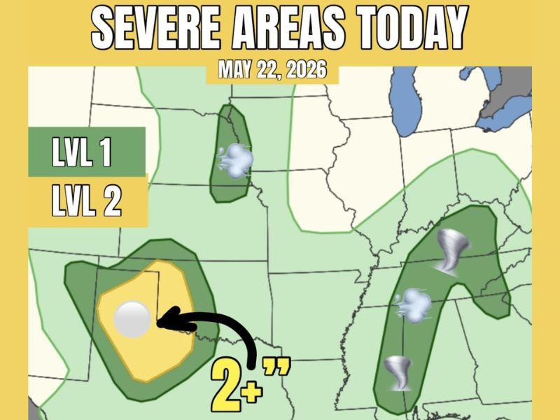
The Texas Panhandle carries the highest risk at Level 2 with very large hail of 2 inches or greater and damaging winds as the primary threats, while central Kentucky through Tennessee faces a low but real tornado chance from low-based severe storms. Eastern Nebraska rounds out the threat with gusty winds and small hail from pulsing severe storms through the day.
Texas Panhandle Facing Level 2 Severe Risk With Very Large Hail Over 2 Inches
The Texas Panhandle is the highest-risk zone on the severe weather map Friday, carrying a Level 2 severe weather designation with very large hail of 2 inches or greater as the headline threat. Higher-based clustered convection will be the primary storm mode across this zone, with damaging winds also possible alongside the significant hail threat.
The Level 2 risk area is clearly defined across the panhandle region with a Level 1 buffer surrounding it extending the overall threat footprint. Residents across the Texas Panhandle should protect vehicles, livestock, and any outdoor property before storms develop Friday.
Brief and Weak Tornado Threat Active From Central Kentucky Through Tennessee to the Gulf Coast
A low but real tornado threat extends from central Kentucky southward through Tennessee and toward the Gulf Coast on Friday. Low-based severe storms with a little shear to work with are capable of producing brief and weak tornadoes across this corridor through the day.
Any tornado that does develop is expected to remain brief and weak in nature given the limited shear available to storms in this zone. However, residents from central Kentucky through Tennessee and into the Gulf Coast corridor should remain weather-aware and have a shelter plan ready through the afternoon and evening hours.
Eastern Nebraska Watching for Gusty Winds and Small Hail From Pulsing Severe Storms
Eastern Nebraska is under a Level 1 severe weather risk Friday, with pulsing severe storms capable of producing gusty winds and pocket change size hail across the region. The storm mode here is less organized than the Texas Panhandle threat but still capable of producing brief hazardous conditions where cells develop.
Residents across eastern Nebraska should monitor conditions through the day and be prepared for quickly changing weather as pulsing storm activity moves through the region. Staying connected to local alerts will be the key to staying ahead of any rapidly developing severe cells Friday.
Stay with NapervilleLocal.com for the latest weather updates and local forecast coverage.

I’ve lived in Naperville long enough to see how quickly our community changes — from new developments downtown to sudden shifts in our Midwest weather. Reporting on Naperville news and daily forecasts gives me the chance to keep neighbors informed about what really matters. My goal is simple: deliver clear, timely updates so you always know what’s happening in our city and what to expect from the skies above.