
Scattered Showers, Thunderstorms, and Mountain Snow Targeting Colorado and Wyoming Including the Front Range, Foothills, and Eastern Plains With Snow Levels Dropping to 8000 Feet Friday
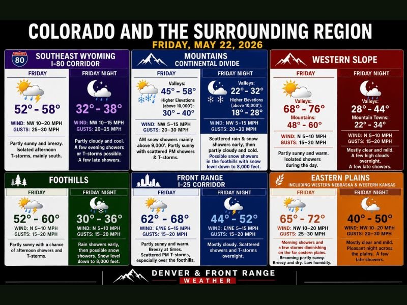
COLORADO AND SURROUNDING REGION — A weak shortwave moving across the region on Friday, May 22, 2026, is delivering a mixed bag of weather conditions across Colorado and Wyoming, ranging from scattered afternoon thunderstorms along the Front Range and I-25 corridor to mountain snow above 9000 feet and residual morning showers diminishing across the eastern plains. Snow levels will drop to near 8000 feet by Friday night across the foothills and Continental Divide, with sneaky snow accumulation possible on grassy surfaces at elevation. The pattern warms and dries considerably into the weekend before Memorial Day brings a return of gusty showers and storms next week.
Mountain and Continental Divide Zones Seeing Snow Above 9000 Feet With Scattered Afternoon Storms
Morning snow showers are occurring mainly above 9000 feet across the Colorado mountains and Continental Divide on Friday, with valley highs ranging from 45 to 58 degrees during the day before dropping sharply to 22 to 32 degrees Friday night. Higher elevations above 10,000 feet will see daytime highs of only 30 to 40 degrees with overnight lows falling to 18 to 28 degrees.
Scattered rain and snow showers continue into Friday night across the higher terrain, with possible snow showers pushing into the foothills as snow levels drop to 8000 feet overnight. Winds across the mountain zones will be northwest at 5 to 15 mph with gusts to 20 to 30 mph through the period.
Front Range and I-25 Corridor Facing Scattered Afternoon Thunderstorms South of I-76
The Front Range and I-25 corridor will see pleasant and partly sunny conditions through much of Friday with temperatures ranging from 62 to 68 degrees, but scattered afternoon thunderstorms are possible with the highest probability focused south of I-76. Winds will be east to northeast at 5 to 15 mph with gusts to 20 mph through the afternoon storm window.
Friday night brings mostly cloudy skies with scattered showers and thunderstorms continuing overnight as temperatures drop to 44 to 52 degrees. The foothills zone mirrors this pattern with partly sunny afternoon conditions giving way to rain showers early Friday night before possible snow showers develop as snow levels drop to 8000 feet overnight.
Eastern Plains Morning Showers Diminishing With Mostly Dry and Breezy Afternoon Ahead
Residual morning showers and a few storms from Thursday’s activity will diminish quickly across the eastern plains including western Nebraska and western Kansas through the Friday morning hours. Afternoon conditions are expected to become partly sunny, breezy, and dry with low humidity as northwest winds of 10 to 20 mph and gusts to 25 to 30 mph sweep across the plains.
Daytime highs across the eastern plains will reach 65 to 72 degrees before dropping to 40 to 50 degrees Friday night under mostly clear and mild conditions. A few late showers are possible overnight but the overall Friday picture for the eastern plains is significantly calmer than the storm activity seen on Thursday.
Warming Weekend Ahead Before Memorial Day Brings Gusty Showers and Storm Risk Monday
Saturday brings a notable warmup with widespread 70s east of the Continental Divide and near 80 on the Western Slope, with only a few extra afternoon clouds and isolated gusty showers possible. Sunday will be approximately 10 degrees warmer across the board, feeling like early summer with gusty winds and increasing cloud cover as the main weather concerns.
Memorial Day Monday starts hot with 80s and low 90s on the eastern plains and 80s on the Western Slope, with gusty showers and storms returning as a real risk through the holiday. The pattern is expected to remain active into Tuesday and beyond as the next weather system moves through the region. Stay with NapervilleLocal.com for the latest weather updates and local forecast coverage.

I’ve lived in Naperville long enough to see how quickly our community changes — from new developments downtown to sudden shifts in our Midwest weather. Reporting on Naperville news and daily forecasts gives me the chance to keep neighbors informed about what really matters. My goal is simple: deliver clear, timely updates so you always know what’s happening in our city and what to expect from the skies above.