
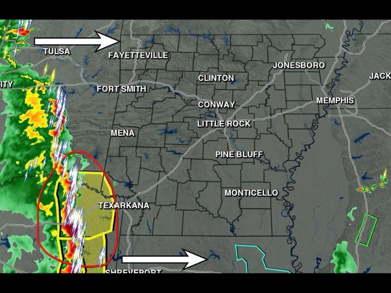
Severe-Capable Storms With Damaging Winds and Heavy Lightning Moving Into Arkansas Including Southwest Arkansas and Texarkana Area Eastward Through the State Saturday Morning
ARKANSAS — A line of storms, some severe, is moving into western Arkansas Saturday morning and will push eastward across the state over the next one to two hours, with the strongest cells already impacting the southwest Arkansas and Texarkana corridor. Damaging winds are the primary severe threat, though the overall risk remains low and most locations will experience rain, thunder, and frequent lightning as the line moves through.
Strongest Storm Cells Targeting Southwest Arkansas and Texarkana Corridor First
Arkansas radar at 6:41AM Saturday shows the strongest storm cores, circled in red, positioned near and just west of the Texarkana area and poised to push into southwest Arkansas imminently. These cells are the most concerning portion of the line and carry the greatest potential for damaging wind gusts as they cross into the state.
A separate storm track is also pushing eastward from the Tulsa direction toward Fayetteville and Fort Smith across the northern portion of the state. Both corridors will need to be monitored closely as the line advances through the morning hours.
Damaging Winds the Main Severe Threat as Line Moves East Through Arkansas
Severe weather in the form of damaging winds is possible with the strongest storms in this line, though forecasters emphasize the overall severe risk is low. The majority of Arkansas residents will experience this system primarily as a rain and thunder event as the line tracks eastward toward Little Rock, Conway, Pine Bluff, and eventually Memphis.
Frequent and significant lightning is occurring with these storms across the entire line. Residents are strongly urged to remain indoors while the storms pass through their area and avoid any outdoor exposure until the line has completely cleared.
Line Expected to Push Through Entire State Over the Next One to Two Hours
The storm line will continue its eastward progression through Arkansas over the next hour or two, impacting communities from Fort Smith and Fayetteville in the northwest through Little Rock, Conway, and Pine Bluff in the central zones before reaching Jonesboro, Memphis, and the eastern border. Timing will be quick as the line moves efficiently across the state.
Staying weather aware and remaining indoors through the morning passage of this system is the safest approach for all Arkansas residents Saturday. The threat will diminish quickly after the line passes, but the lightning risk alone warrants staying inside until storms have fully cleared the local area. Stay with NapervilleLocal.com for the latest weather updates and local forecast coverage.

I’ve lived in Naperville long enough to see how quickly our community changes — from new developments downtown to sudden shifts in our Midwest weather. Reporting on Naperville news and daily forecasts gives me the chance to keep neighbors informed about what really matters. My goal is simple: deliver clear, timely updates so you always know what’s happening in our city and what to expect from the skies above.